
Topografische kaart Beaverton
Interactieve kaart
Klik op de kaart om de hoogte weer te geven.
Over deze kaart
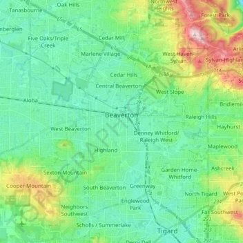
Naam: Topografische kaart Beaverton, hoogte, reliëf.
Locatie: Beaverton, Washington County, Oregon, United States (45.42459 -122.87772 45.54296 -122.74366)
Gemiddelde hoogte: 106 m
Minimale hoogte: 15 m
Maximale hoogte: 386 m
As of January 2020, Beaverton covers a total area of 19.7 square miles (51 km2), all of it land except for small creeks, ponds, and lakes. The city is located along the eastern edge of the Tualatin Valley just west of the Tualatin Mountains. It is bordered by Portland to the east, Hillsboro to the west, and Tigard to the south. Much of the remaining area surrounding Beaverton in the north and southwest constitutes unincorporated Washington County land. The elevation within city limits ranges from as high as 698.2 feet (212.8 m) above sea level to as low as 131.7 feet (40.1 m) above sea level. The city averages at 189 feet (58 m) above sea level.
Andere topografische kaarten
Klik op een kaart om zijn topografie, zijn hoogte en zijn reliëf te bekijken.
Vern Galaway Memorial Park
United States > Oregon > Washington County > North Plains
Vern Galaway Memorial Park, North Plains, Washington County, Oregon, United States
Gemiddelde hoogte: 56 m
Tualatin
United States > Oregon > Washington County
Tualatin, Washington County, Oregon, 97062, United States
Gemiddelde hoogte: 70 m
Cornelius
United States > Oregon > Washington County > Cornelius
Cornelius, Washington County, Oregon, United States
Gemiddelde hoogte: 51 m
Banks
United States > Oregon > Washington County
Banks, Washington County, Oregon, 97106, United States
Gemiddelde hoogte: 70 m
Hillsboro
United States > Oregon > Washington County
Hillsboro, Washington County, Oregon, United States
Gemiddelde hoogte: 53 m
Tigard
United States > Oregon > Washington County
Tigard, Washington County, Oregon, United States
Gemiddelde hoogte: 83 m