
Topografische kaart Obsidian Cliff
Interactieve kaart
Klik op de kaart om de hoogte weer te geven.
Over deze kaart
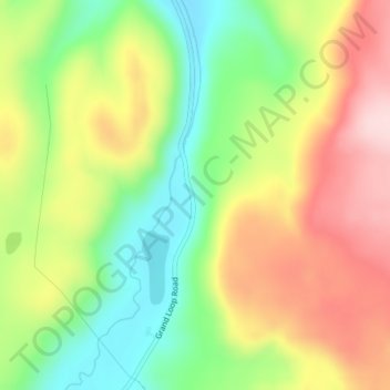
Naam: Topografische kaart Obsidian Cliff, hoogte, reliëf.
Locatie: Obsidian Cliff, Park County, Wyoming, United States (44.82081 -110.72762 44.82091 -110.72752)
Gemiddelde hoogte: 2.361 m
Minimale hoogte: 2.238 m
Maximale hoogte: 2.499 m
The cliff was formed from thick rhyolite lava flow that occurred about 180,000 years ago. The vertical columns are cooling fractures that formed as the thick lava flow cooled and crystallized. The Cliffs stands at an elevation of nearly 7,400 feet (2,300 m) above sea level and goes on for about half a mile. The cliffs also extend between 150 and 200 feet above Obsidian Creek. The flow consists of obsidian, a dark volcanic glass. The obsidian is most abundant at the base of the cliff and slowly tapers off to larger concentrations of pumice at the top. Obsidian from this site was first quarried here about 12,000 years ago. Early natives of North America placed a high value on the obsidian that came from this cliff as well as other similar obsidian deposits in the area because numerous tools could be fashioned from obsidian—most popularly, knives, spear/arrow tips, and other sharp-edged objects. In fact, obsidian from Obsidian Cliff was so sought after in early America (before the time of Columbus) that it was traded as far away as Ohio and Canada.
Andere topografische kaarten
Klik op een kaart om zijn topografie, zijn hoogte en zijn reliëf te bekijken.
Yellowstone National Park
United States > Wyoming > Park County
Yellowstone National Park, Park County, Wyoming, United States
Gemiddelde hoogte: 2.450 m
Sawtooth
United States > Wyoming > Park County
Sawtooth, Park County, Wyoming, United States
Gemiddelde hoogte: 1.718 m
Canyon Village
United States > Wyoming > Park County
Canyon Village, Park County, Wyoming, 82190, United States
Gemiddelde hoogte: 2.418 m
Dome Mountain
United States > Wyoming > Park County
Dome Mountain, Park County, Wyoming, United States
Gemiddelde hoogte: 2.647 m
Mount Everts
United States > Wyoming > Park County
Mount Everts, Park County, Wyoming, United States
Gemiddelde hoogte: 2.192 m
Clark
United States > Wyoming > Park County
Clark, Park County, Wyoming, United States
Gemiddelde hoogte: 1.289 m
Mount Washburn
United States > Wyoming > Park County
Mount Washburn, Park County, Wyoming, United States
Gemiddelde hoogte: 2.798 m
Cody
United States > Wyoming > Park County
Cody, Park County, Wyoming, United States
Gemiddelde hoogte: 1.557 m
Sunlight Bridge Overlook
United States > Wyoming > Park County
Sunlight Bridge Overlook, Chief Joseph Highway, Park County, Wyoming, United States
Gemiddelde hoogte: 1.921 m
Hayden Valley
United States > Wyoming > Park County
Hayden Valley, Park County, Wyoming, United States
Gemiddelde hoogte: 2.373 m
Inspiration Point
United States > Wyoming > Park County
Inspiration Point, North Rim Trail, Park County, Wyoming, 82190, United States
Gemiddelde hoogte: 2.367 m
Powell
United States > Wyoming > Park County > Powell
Powell, Park County, Wyoming, United States
Gemiddelde hoogte: 1.391 m
Meeteetse
United States > Wyoming > Park County
Meeteetse, Park County, Wyoming, United States
Gemiddelde hoogte: 1.791 m
Wapiti
United States > Wyoming > Park County
Wapiti, Park County, Wyoming, 82450, United States
Gemiddelde hoogte: 1.794 m