
Doe een donatie
Rust jezelf uit voor je volgende avontuur:
Als Amazon-partner verdient deze site een commissie op in aanmerking komende aankopen, zonder extra kosten voor jou.
Topografische kaart Reineberg
Klik op de kaart om de hoogte weer te geven.
Doe een donatie
Rust jezelf uit voor je volgende avontuur:
Als Amazon-partner verdient deze site een commissie op in aanmerking komende aankopen, zonder extra kosten voor jou.
Reineberg
The Reineberg is a hill on the Wiehen ridge, south of the town of Lübbecke. With a height of 275.9 m above sea level it is, from a topographical point of view, not a particularly impressive eminence in this part of the Wiehen Hills, because, in the immediate vicinity are considerably higher summits, such as the 320 m high Heidbrink just under 1 km to the south. East of the Reinberg on the other side of a valley bottom rises the Heidkopf, west of the Meesenkopf, on the summit of which there was once a fortification. 230 metres southwest of the summit lies the Wittekind Spring, that had a certain importance for the garrison of the castle at the summit, but today is just a small pond by a rock outcrop at the edge of a track. The Reineberg, which is the local hill for the town of Lübbecke, owes its significance to the fact that, until 1723, the year of its demolition, Reineberg Castle (German: Burg Reineberg or Reineburg) stood here.
Doe een donatie
Rust jezelf uit voor je volgende avontuur:
Als Amazon-partner verdient deze site een commissie op in aanmerking komende aankopen, zonder extra kosten voor jou.
Over deze kaart
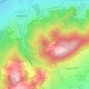
Naam: Topografische kaart Reineberg, hoogte, reliëf.
Gemiddelde hoogte: 181 m
Minimale hoogte: 69 m
Maximale hoogte: 310 m
Doe een donatie
Rust jezelf uit voor je volgende avontuur:
Als Amazon-partner verdient deze site een commissie op in aanmerking komende aankopen, zonder extra kosten voor jou.
Andere topografische kaarten
Klik op een kaart om zijn topografie, zijn hoogte en zijn reliëf te bekijken.