
Topografische kaart Ocean Springs
Interactieve kaart
Klik op de kaart om de hoogte weer te geven.
Over deze kaart
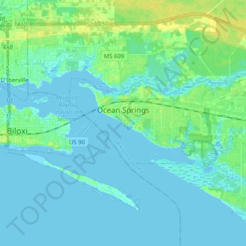
Naam: Topografische kaart Ocean Springs, hoogte, reliëf.
Locatie: Ocean Springs, Jackson County, Mississippi, United States (30.38120 -88.86184 30.42801 -88.71941)
Gemiddelde hoogte: 4 m
Minimale hoogte: -4 m
Maximale hoogte: 18 m
Andere topografische kaarten
Klik op een kaart om zijn topografie, zijn hoogte en zijn reliëf te bekijken.
Marine Education Center
United States > Mississippi > Jackson County > Ocean Springs
Marine Education Center, Laurel Oak Drive, Ocean Springs, Jackson County, Mississippi, 39564, United States
Gemiddelde hoogte: 4 m
Channel Island
United States > Mississippi > Jackson County > Ocean Springs
Channel Island, Ocean Springs, Jackson County, Mississippi, 39533, United States
Gemiddelde hoogte: 11 m