
Topografische kaart Groton
Interactieve kaart
Klik op de kaart om de hoogte weer te geven.
Over deze kaart
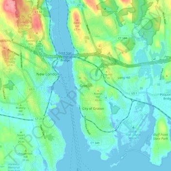
Naam: Topografische kaart Groton, hoogte, reliëf.
Locatie: Groton, New London County, Connecticut, 06340, United States (41.31016 -72.11620 41.39016 -72.03620)
Gemiddelde hoogte: 21 m
Minimale hoogte: -3 m
Maximale hoogte: 91 m
Andere topografische kaarten
Klik op een kaart om zijn topografie, zijn hoogte en zijn reliëf te bekijken.
Groton Long Point
United States > Connecticut > New London County > Groton > Groton Long Point
Groton Long Point, Groton, New London County, Connecticut, United States
Gemiddelde hoogte: 2 m
Noank
United States > Connecticut > New London County > Groton > Noank
Noank, Groton, New London County, Connecticut, United States
Gemiddelde hoogte: 15 m
Poquonock Bridge
United States > Connecticut > New London County > Groton > Poquonock Bridge
Poquonock Bridge, Groton, New London County, Connecticut, United States
Gemiddelde hoogte: 20 m