
Topografische kaart County Antrim
Interactieve kaart
Klik op de kaart om de hoogte weer te geven.
Over deze kaart
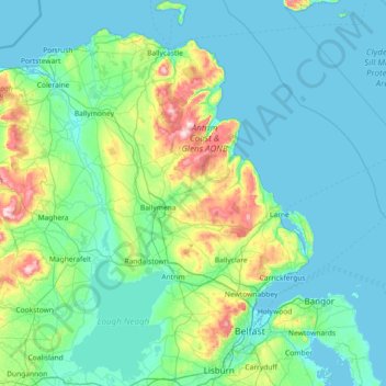
Naam: Topografische kaart County Antrim, hoogte, reliëf.
Locatie: County Antrim, Nordirland, Vereinigtes Königreich (54.47728 -6.66899 55.31309 -5.68796)
Gemiddelde hoogte: 70 m
Minimale hoogte: -1 m
Maximale hoogte: 549 m
Andere topografische kaarten
Klik op een kaart om zijn topografie, zijn hoogte en zijn reliëf te bekijken.
Glenoe
Vereinigtes Königreich > Nordirland > County Antrim > Glenoe
Glenoe, County Antrim, Nordirland, BT40 3DU, Vereinigtes Königreich
Gemiddelde hoogte: 144 m
Bushmills
Vereinigtes Königreich > Nordirland > County Antrim > Bushmills
Bushmills, County Antrim, Nordirland, BT57 8QB, Vereinigtes Königreich
Gemiddelde hoogte: 42 m
Ballyrobert
Vereinigtes Königreich > Nordirland > County Antrim > Ballyrobert
Ballyrobert, County Antrim, Nordirland, BT39 9RX, Vereinigtes Königreich
Gemiddelde hoogte: 106 m