
Topografische kaart Oswego
Interactieve kaart
Klik op de kaart om de hoogte weer te geven.
Over deze kaart
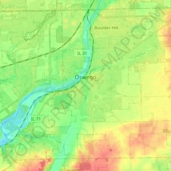
Naam: Topografische kaart Oswego, hoogte, reliëf.
Gemiddelde hoogte: 203 m
Minimale hoogte: 178 m
Maximale hoogte: 236 m
Andere topografische kaarten
Klik op een kaart om zijn topografie, zijn hoogte en zijn reliëf te bekijken.
Plattville
United States > Illinois > Kendall County
Plattville, Lisbon Township, Kendall County, Illinois, United States
Gemiddelde hoogte: 185 m
Yorkville
United States > Illinois > Kendall County
Yorkville, Kendall Township, Kendall County, Illinois, 60560, United States
Gemiddelde hoogte: 203 m
Lisbon
United States > Illinois > Kendall County
Lisbon, Lisbon Township, Kendall County, Illinois, United States
Gemiddelde hoogte: 200 m
Plano
United States > Illinois > Kendall County
Plano, Little Rock Township, Kendall County, Illinois, 60545, United States
Gemiddelde hoogte: 202 m
Montgomery
United States > Illinois > Kendall County
Montgomery, Oswego Township, Kendall County, Illinois, 60538, United States
Gemiddelde hoogte: 208 m