
Topografische kaart Municipality of Patras
Interactieve kaart
Klik op de kaart om de hoogte weer te geven.
Over deze kaart
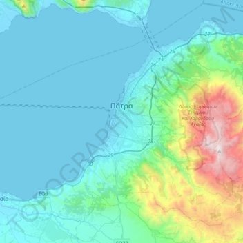
Naam: Topografische kaart Municipality of Patras, hoogte, reliëf.
Gemiddelde hoogte: 291 m
Minimale hoogte: -4 m
Maximale hoogte: 1.924 m
A central feature of the urban geography of Patras is its division into upper and lower sections. This is the result of an interplay between natural geography and human settlement patterns; the lower section of the city (Kato Poli), which includes the 19th-century urban core and the port, is adjacent to the sea and stretches between the estuaries of the rivers of Glafkos and Haradros. It is built on what was originally a bed of river soils and dried-up swamps. The older upper section (Ano Poli) covers the area of the pre-modern settlement, around the Fortress, on what is the last elevation of Mount Panachaikon (1,926 m (6,319 ft)) before the Gulf of Patras.
Andere topografische kaarten
Klik op een kaart om zijn topografie, zijn hoogte en zijn reliëf te bekijken.
Aigio
Greece > Peloponnese, Western Greece and the Ionian > Achaia Regional Unit
Aigio, Municipal Unit of Aegio, Municipality of Aigialeia, Achaia Regional Unit, Western Greece, Peloponnese, Western Greece and the Ionian, 251 00, Greece
Gemiddelde hoogte: 371 m
Patras
Greece > Peloponnese, Western Greece and the Ionian > Achaia Regional Unit
Patras, Municipal Unit of Patras, Municipality of Patras, Achaia Regional Unit, Western Greece, Peloponnese, Western Greece and the Ionian, 262 21, Greece
Gemiddelde hoogte: 283 m