
Topografische kaart Zeeland
Interactieve kaart
Klik op de kaart om de hoogte weer te geven.
Over deze kaart
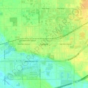
Naam: Topografische kaart Zeeland, hoogte, reliëf.
Locatie: Zeeland, Ottawa County, Michigan, 49464, United States (42.79790 -86.03850 42.82690 -85.98896)
Gemiddelde hoogte: 192 m
Minimale hoogte: 178 m
Maximale hoogte: 203 m
According to the United States Census Bureau, the city has a total area of 3.01 square miles (7.80 km2), of which 2.99 square miles (7.74 km2) is land and 0.02 square miles (0.05 km2) is water. The town itself is located on a hill, giving the city a higher elevation compared to the surrounding township land. Much of the outlying areas contain farmland and forest.
Andere topografische kaarten
Klik op een kaart om zijn topografie, zijn hoogte en zijn reliëf te bekijken.
Georgetown Charter Township
United States > Michigan > Ottawa County
Georgetown Charter Township, Ottawa County, Michigan, 49428, United States
Gemiddelde hoogte: 199 m
Port Sheldon
United States > Michigan > Ottawa County
Port Sheldon, Port Sheldon Township, Ottawa County, Michigan, United States
Gemiddelde hoogte: 185 m
Polkton Township
United States > Michigan > Ottawa County
Polkton Township, Ottawa County, Michigan, United States
Gemiddelde hoogte: 195 m
Coopersville
United States > Michigan > Ottawa County
Coopersville, Ottawa County, Michigan, 49404, United States
Gemiddelde hoogte: 200 m
Holland
United States > Michigan > Ottawa County > Holland
Holland, Ottawa County, Michigan, 49423, United States
Gemiddelde hoogte: 199 m
Allendale
United States > Michigan > Ottawa County > Allendale
Allendale, Allendale Charter Township, Ottawa County, Michigan, 49401, United States
Gemiddelde hoogte: 195 m
Chester Township
United States > Michigan > Ottawa County
Chester Township, Ottawa County, Michigan, 49403, United States
Gemiddelde hoogte: 233 m