
Topografische kaart Madulain
Interactieve kaart
Klik op de kaart om de hoogte weer te geven.
Madulain
Before 2017, the municipality was located in the Oberengadin sub-district of the Maloja district, after 2017 it was part of the Maloja Region. It is the smallest of the eleven municipalities in the district. It is located in the upper Engadin valley between La Punt Chamues-ch and Zuoz about 15 minutes from St. Moritz on the Inn River. It consists of the Haufendorf village (an irregular, unplanned and quite closely packed village, built around a central square) of Madulain on the Inn at an elevation of 1,684 m (5,525 ft). Until 1943 Madulain was known as Madulein.
Over deze kaart
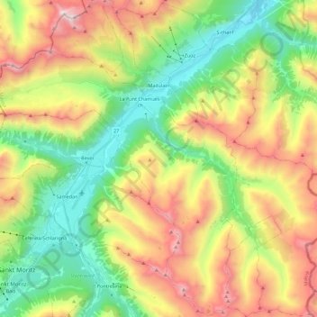
Naam: Topografische kaart Madulain, hoogte, reliëf.
Locatie: Madulain, Maloja, Grisons, 7523, Switzerland (46.47497 9.89879 46.62785 10.02502)
Gemiddelde hoogte: 2.330 m
Minimale hoogte: 1.627 m
Maximale hoogte: 3.393 m