
Topografische kaart Adobe Dam
Interactieve kaart
Klik op de kaart om de hoogte weer te geven.
Over deze kaart
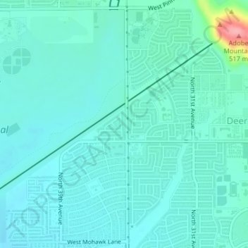
Naam: Topografische kaart Adobe Dam, hoogte, reliëf.
Gemiddelde hoogte: 421 m
Minimale hoogte: 404 m
Maximale hoogte: 518 m
Andere topografische kaarten
Klik op een kaart om zijn topografie, zijn hoogte en zijn reliëf te bekijken.
Phoenix
United States > Arizona > Maricopa County > Phoenix
Phoenix, Maricopa County, Arizona, 85004-1905, United States
Gemiddelde hoogte: 368 m
Desert West Lake
United States > Arizona > Maricopa County > Phoenix
Desert West Lake, 6602, County Fair West, Phoenix, Maricopa County, Arizona, 85035, United States
Gemiddelde hoogte: 330 m
Camelback Mountain
United States > Arizona > Maricopa County > Phoenix
Camelback Mountain, Phoenix, Maricopa County, Arizona, 85018, United States
Gemiddelde hoogte: 462 m
Arizona Falls
United States > Arizona > Maricopa County > Phoenix
Arizona Falls, Phoenix, Maricopa County, Arizona, 85018, United States
Gemiddelde hoogte: 390 m
Chinese Wall
United States > Arizona > Maricopa County > Phoenix
Chinese Wall, Phoenix, Maricopa County, Arizona, 85042, United States
Gemiddelde hoogte: 641 m
Desert Botanical Garden
United States > Arizona > Maricopa County > Phoenix
Desert Botanical Garden, Phoenix, Maricopa County, Arizona, United States
Gemiddelde hoogte: 389 m
New River
United States > Arizona > Maricopa County > Phoenix
New River, Phoenix, Maricopa County, Arizona, United States
Gemiddelde hoogte: 690 m
Union Peak
United States > Arizona > Maricopa County > Phoenix
Union Peak, Phoenix, Maricopa County, Arizona, United States
Gemiddelde hoogte: 527 m
Union Hills
United States > Arizona > Maricopa County > Phoenix
Union Hills, Phoenix, Maricopa County, Arizona, 85024-5118, United States
Gemiddelde hoogte: 506 m