
Topografische kaart Ngwathe Ward 18
Interactieve kaart
Klik op de kaart om de hoogte weer te geven.
Over deze kaart
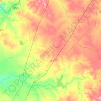
Naam: Topografische kaart Ngwathe Ward 18, hoogte, reliëf.
Gemiddelde hoogte: 1.443 m
Minimale hoogte: 1.340 m
Maximale hoogte: 1.575 m
Andere topografische kaarten
Klik op een kaart om zijn topografie, zijn hoogte en zijn reliëf te bekijken.
Ngwathe Ward 13
RSA > Free State > Ngwathe Local Municipality
Ngwathe Ward 13, Ngwathe Local Municipality, Fezile Dabi District Municipality, Free State, RSA
Gemiddelde hoogte: 1.407 m