
Topografische kaart Santa Rosa
Interactieve kaart
Klik op de kaart om de hoogte weer te geven.
Over deze kaart
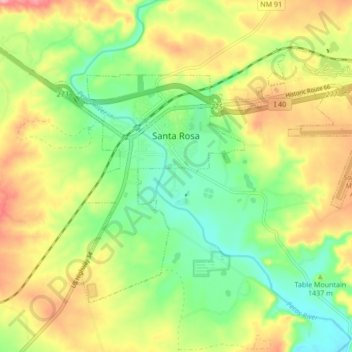
Naam: Topografische kaart Santa Rosa, hoogte, reliëf.
Locatie: Santa Rosa, Guadalupe County, New Mexico, United States (34.90537 -104.71476 34.95589 -104.62953)
Gemiddelde hoogte: 1.424 m
Minimale hoogte: 1.370 m
Maximale hoogte: 1.493 m
Andere topografische kaarten
Klik op een kaart om zijn topografie, zijn hoogte en zijn reliëf te bekijken.
Tejon
United States > New Mexico > Guadalupe County
Tejon, Guadalupe County, New Mexico, United States
Gemiddelde hoogte: 1.861 m
Cuervo
United States > New Mexico > Guadalupe County
Cuervo, Guadalupe County, New Mexico, United States
Gemiddelde hoogte: 1.502 m
Santa Rosa Lake State Park
United States > New Mexico > Guadalupe County
Santa Rosa Lake State Park, Guadalupe County, New Mexico, United States
Gemiddelde hoogte: 1.465 m
Vaughn
United States > New Mexico > Guadalupe County
Vaughn, Guadalupe County, New Mexico, 88353, United States
Gemiddelde hoogte: 1.816 m