
Topografische kaart South Ilion
Interactieve kaart
Klik op de kaart om de hoogte weer te geven.
Over deze kaart
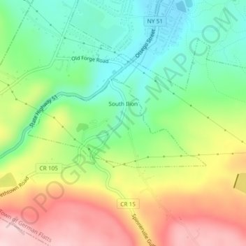
Naam: Topografische kaart South Ilion, hoogte, reliëf.
Gemiddelde hoogte: 239 m
Minimale hoogte: 135 m
Maximale hoogte: 381 m
Andere topografische kaarten
Klik op een kaart om zijn topografie, zijn hoogte en zijn reliëf te bekijken.
Village of Mohawk
United States > New York > Herkimer County > Town of German Flatts
Village of Mohawk, Town of German Flatts, Herkimer County, New York, United States
Gemiddelde hoogte: 148 m
Dennison Corners
United States > New York > Herkimer County > Town of German Flatts
Dennison Corners, Town of German Flatts, Herkimer County, New York, 13407, United States
Gemiddelde hoogte: 404 m
Edicks
United States > New York > Herkimer County > Town of German Flatts
Edicks, Town of German Flatts, Herkimer County, New York, United States
Gemiddelde hoogte: 355 m
Days Rock
United States > New York > Herkimer County > Town of German Flatts
Days Rock, Town of German Flatts, Herkimer County, New York, 13407, United States
Gemiddelde hoogte: 317 m
Fort Herkimer
United States > New York > Herkimer County > Town of German Flatts
Fort Herkimer, Town of German Flatts, Herkimer County, New York, 13350, United States
Gemiddelde hoogte: 177 m
Village of Ilion
United States > New York > Herkimer County > Town of German Flatts
Village of Ilion, Town of German Flatts, Herkimer County, New York, 13357, United States
Gemiddelde hoogte: 151 m