
Topografische kaart Rayleigh
Klik op de kaart om de hoogte weer te geven.
Over deze kaart
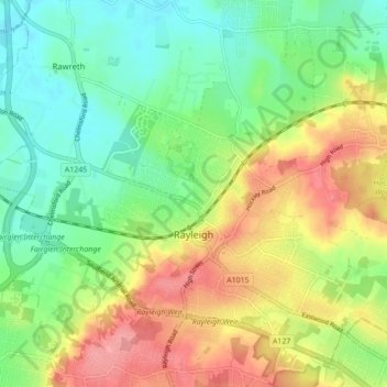
Naam: Topografische kaart Rayleigh, hoogte, reliëf.
Locatie: Rayleigh, Rochford, Essex, England, United Kingdom (51.57052 0.56227 51.61781 0.64926)
Gemiddelde hoogte: 37 m
Minimale hoogte: 1 m
Maximale hoogte: 86 m
Andere topografische kaarten
Klik op een kaart om zijn topografie, zijn hoogte en zijn reliëf te bekijken.
Hedingham Castle
United Kingdom > England > Essex > Braintree > Castle Hedingham
Gemiddelde hoogte: 67 m
Coles Green
United Kingdom > England > Essex > Uttlesford > Berden > Little London
Gemiddelde hoogte: 100 m
Nazeing Gate
United Kingdom > England > Essex > Epping Forest > Bumble's Green > Nazeing
Gemiddelde hoogte: 70 m
Roughtalley's Wood (South) & Epping Forest Woodland Burial Ground
United Kingdom > England > Essex > Epping Forest > Coopersale
Gemiddelde hoogte: 96 m
Watch House Green
United Kingdom > England > Essex > Uttlesford > Felsted > Watch House Green
Gemiddelde hoogte: 69 m
Wivenhoe Woods
United Kingdom > England > Essex > Colchester > Wivenhoe > Rowhedge
Gemiddelde hoogte: 18 m
M25 Pollution Control Device
United Kingdom > England > Essex > South Ockendon
Gemiddelde hoogte: 19 m