
Topografische kaart Ingleton
Interactieve kaart
Klik op de kaart om de hoogte weer te geven.
Over deze kaart
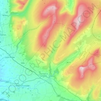
Naam: Topografische kaart Ingleton, hoogte, reliëf.
Locatie: Ingleton, North Yorkshire, England, United Kingdom (54.12331 -2.50878 54.25714 -2.28640)
Gemiddelde hoogte: 309 m
Minimale hoogte: 39 m
Maximale hoogte: 733 m
Andere topografische kaarten
Klik op een kaart om zijn topografie, zijn hoogte en zijn reliëf te bekijken.
Skipton
United Kingdom > England > North Yorkshire
Skipton, North Yorkshire, England, United Kingdom
Gemiddelde hoogte: 173 m
Swilla Glen
United Kingdom > England > North Yorkshire > Thornton in Lonsdale
Swilla Glen, Thornton in Lonsdale, North Yorkshire, England, LA6 3JJ, United Kingdom
Gemiddelde hoogte: 204 m
Settle
United Kingdom > England > North Yorkshire
Settle, North Yorkshire, England, United Kingdom
Gemiddelde hoogte: 238 m
Pen-y-ghent
United Kingdom > England > North Yorkshire
Pen-y-ghent, North Yorkshire, England, BD24 9PW, United Kingdom
Gemiddelde hoogte: 487 m
Appletreewick
United Kingdom > England > North Yorkshire
Appletreewick, North Yorkshire, England, United Kingdom
Gemiddelde hoogte: 348 m
Catterick
United Kingdom > England > North Yorkshire
Catterick, North Yorkshire, England, United Kingdom
Gemiddelde hoogte: 61 m
Harrogate
United Kingdom > England > North Yorkshire
Harrogate, North Yorkshire, England, United Kingdom
Gemiddelde hoogte: 131 m
Bentham
United Kingdom > England > North Yorkshire > Craven District
Bentham, Craven District, North Yorkshire, England, United Kingdom
Gemiddelde hoogte: 168 m
Muker
United Kingdom > England > North Yorkshire
Muker, North Yorkshire, England, United Kingdom
Gemiddelde hoogte: 479 m