
Topografische kaart Ochotnica Dolna
Interactieve kaart
Klik op de kaart om de hoogte weer te geven.
Over deze kaart
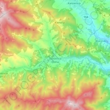
Naam: Topografische kaart Ochotnica Dolna, hoogte, reliëf.
Gemiddelde hoogte: 715 m
Minimale hoogte: 376 m
Maximale hoogte: 1.215 m
Andere topografische kaarten
Klik op een kaart om zijn topografie, zijn hoogte en zijn reliëf te bekijken.
Gronków
Poland > Lesser Poland Voivodeship > Nowy Targ County
Gronków, gmina Nowy Targ, Nowy Targ County, Lesser Poland Voivodeship, Poland
Gemiddelde hoogte: 628 m
Rabka-Zdrój
Poland > Lesser Poland Voivodeship > Nowy Targ County
Rabka-Zdrój, gmina Rabka-Zdrój, Nowy Targ County, Lesser Poland Voivodeship, 34-700, Poland
Gemiddelde hoogte: 594 m
Nowy Targ
Poland > Lesser Poland Voivodeship > Nowy Targ County > Nowy Targ
Nowy Targ, Nowy Targ County, Lesser Poland Voivodeship, Poland
Gemiddelde hoogte: 676 m