
Doe een donatie
Rust jezelf uit voor je volgende avontuur:
Als Amazon-partner verdient deze site een commissie op in aanmerking komende aankopen, zonder extra kosten voor jou.
Topografische kaart Calvià
Klik op de kaart om de hoogte weer te geven.
Doe een donatie
Rust jezelf uit voor je volgende avontuur:
Als Amazon-partner verdient deze site een commissie op in aanmerking komende aankopen, zonder extra kosten voor jou.
Calvià
Calvià first appears in history as a village 2,000 years BCE, although the area was first populated in the Neolithic Era. Later, sailors coming from the east stopped in the Balearics on their way to the Iberian Peninsula, where they sought metals. They came from Italy, from other Mediterranean islands, and from the Near East, and constructed small settlements along the coast. Historians call this period the "Cave Culture", because caves were frequently used as habitations and burial areas. Some vestiges of this area have been catalogued in an archaeological excavation called the Puig de sa Morisca Archaeological Park, which conserves remains of what was a talaiot 9 metres (30 ft) in diameter. It is located on a small mountainous elevation in Calvià's Santa Ponsa district.
Doe een donatie
Rust jezelf uit voor je volgende avontuur:
Als Amazon-partner verdient deze site een commissie op in aanmerking komende aankopen, zonder extra kosten voor jou.
Over deze kaart
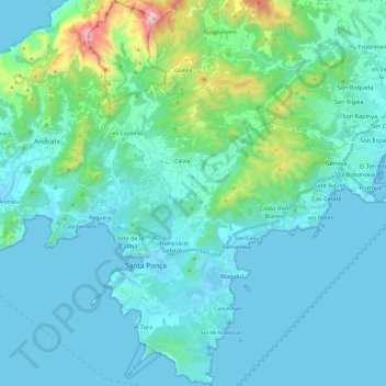
Naam: Topografische kaart Calvià, hoogte, reliëf.
Locatie: Calvià, Serra de Tramuntana, Balearic Islands, Spain (39.45671 2.42185 39.64237 2.59803)
Gemiddelde hoogte: 134 m
Minimale hoogte: -1 m
Maximale hoogte: 1.017 m
Doe een donatie
Rust jezelf uit voor je volgende avontuur:
Als Amazon-partner verdient deze site een commissie op in aanmerking komende aankopen, zonder extra kosten voor jou.
Andere topografische kaarten
Klik op een kaart om zijn topografie, zijn hoogte en zijn reliëf te bekijken.
Serra de Tramuntana
Spain > Balearic Islands > Serra de Tramuntana
The climate in the Tramuntana Range is significantly wetter than the rest of the island, recording as much as 1507 mm (59.3 inches) of precipitation per year, in comparison with some other parts of the island where annual rainfall is less than 400mm (15 inch). It is also cooler due to the altitude, and a few…
Gemiddelde hoogte: 175 m
Doe een donatie
Rust jezelf uit voor je volgende avontuur:
Als Amazon-partner verdient deze site een commissie op in aanmerking komende aankopen, zonder extra kosten voor jou.
Mirador d'es Colomer
Spain > Balearic Islands > Serra de Tramuntana > Port de Pollença
Gemiddelde hoogte: 79 m
Doe een donatie
Rust jezelf uit voor je volgende avontuur:
Als Amazon-partner verdient deze site een commissie op in aanmerking komende aankopen, zonder extra kosten voor jou.
Puig Major
Spain > Balearic Islands > Serra de Tramuntana > Escorca
Puig Major is the highest peak on the Spanish island of Majorca. With an elevation of 1,436 m (4,711 ft) above sea level. It is situated in the Serra de Tramuntana mountains. As the mountain is located in a military zone, the neighbouring peak Puig de Massanella (1,364 m) is considered the highest accessible…
Gemiddelde hoogte: 949 m
Doe een donatie
Rust jezelf uit voor je volgende avontuur:
Als Amazon-partner verdient deze site een commissie op in aanmerking komende aankopen, zonder extra kosten voor jou.
Cova de ses Bruixes
Spain > Balearic Islands > Serra de Tramuntana > Pollença
Gemiddelde hoogte: 143 m
Serra de Tramuntana
Spain > Balearic Islands > Serra de Tramuntana
The climate in the Tramuntana Range is significantly wetter than the rest of the island, recording as much as 1507 mm (59.3 inches) of precipitation per year, in comparison with some other parts of the island where annual rainfall is less than 400mm (15 inch). It is also cooler due to the altitude, and a few…
Gemiddelde hoogte: 175 m
Doe een donatie
Rust jezelf uit voor je volgende avontuur:
Als Amazon-partner verdient deze site een commissie op in aanmerking komende aankopen, zonder extra kosten voor jou.