
Topografische kaart La Porte
Interactieve kaart
Klik op de kaart om de hoogte weer te geven.
Over deze kaart
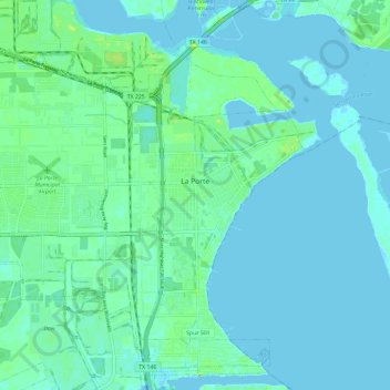
Naam: Topografische kaart La Porte, hoogte, reliëf.
Locatie: La Porte, Harris County, Texas, 77571, United States (29.61491 -95.11270 29.70932 -94.99470)
Gemiddelde hoogte: 4 m
Minimale hoogte: -2 m
Maximale hoogte: 20 m
Andere topografische kaarten
Klik op een kaart om zijn topografie, zijn hoogte en zijn reliëf te bekijken.
Bellaire
United States > Texas > Harris County
Bellaire, Harris County, Texas, United States
Gemiddelde hoogte: 20 m
Baytown
United States > Texas > Harris County
Baytown, Harris County, Texas, United States
Gemiddelde hoogte: 7 m
Memorial Park
United States > Texas > Harris County > Houston
Memorial Park, Houston, Harris County, Texas, 77007, United States
Gemiddelde hoogte: 21 m
Houston
United States > Texas > Harris County
Houston, Harris County, Texas, United States
Gemiddelde hoogte: 25 m
Pasadena
United States > Texas > Harris County
Pasadena, Harris County, Texas, United States
Gemiddelde hoogte: 11 m
Spring Valley
United States > Texas > Harris County
Spring Valley, Harris County, Texas, United States
Gemiddelde hoogte: 25 m
Spring
United States > Texas > Harris County
Spring, Harris County, Texas, 77373, United States
Gemiddelde hoogte: 35 m