
Topografische kaart Banff
Interactieve kaart
Klik op de kaart om de hoogte weer te geven.
Over deze kaart
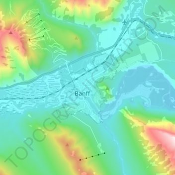
Naam: Topografische kaart Banff, hoogte, reliëf.
Locatie: Banff, Alberta, T1L 1A6, Canada (51.13778 -115.60825 51.21778 -115.52825)
Gemiddelde hoogte: 1.615 m
Minimale hoogte: 1.342 m
Maximale hoogte: 2.745 m
Banff is a town within Banff National Park in Alberta, Canada. It is located in Alberta's Rockies along the Trans-Canada Highway, approximately 126 km (78 mi) west of Calgary and 58 km (36 mi) east of Lake Louise. At 1,400 to 1,630 m (4,590 to 5,350 ft) above sea level, Banff is the community with the second highest elevation in Alberta, after Lake Louise.