
Topografische kaart Prairie Lake
Interactieve kaart
Klik op de kaart om de hoogte weer te geven.
Over deze kaart
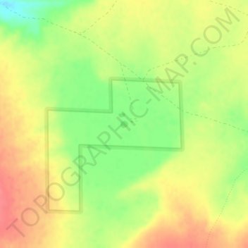
Naam: Topografische kaart Prairie Lake, hoogte, reliëf.
Locatie: Prairie Lake, Catron County, New Mexico, United States (33.70153 -108.01266 33.70233 -108.01171)
Gemiddelde hoogte: 2.342 m
Minimale hoogte: 2.305 m
Maximale hoogte: 2.370 m
Andere topografische kaarten
Klik op een kaart om zijn topografie, zijn hoogte en zijn reliëf te bekijken.
San Francisco
United States > New Mexico > Catron County
San Francisco, Catron County, New Mexico, United States
Gemiddelde hoogte: 2.440 m
Quemado
United States > New Mexico > Catron County
Quemado, Catron County, New Mexico, United States
Gemiddelde hoogte: 2.113 m
Alma
United States > New Mexico > Catron County
Alma, Catron County, New Mexico, United States
Gemiddelde hoogte: 1.535 m
Capital Dome
United States > New Mexico > Catron County
Capital Dome, Catron County, New Mexico, United States
Gemiddelde hoogte: 2.459 m
Cruzville
United States > New Mexico > Catron County
Cruzville, Catron County, New Mexico, United States
Gemiddelde hoogte: 1.975 m
Reserve
United States > New Mexico > Catron County
Reserve, Catron County, New Mexico, United States
Gemiddelde hoogte: 1.780 m
Datil
United States > New Mexico > Catron County
Datil, Catron County, New Mexico, United States
Gemiddelde hoogte: 2.279 m
Gila Wilderness
United States > New Mexico > Catron County
Gila Wilderness, Catron County, New Mexico, United States
Gemiddelde hoogte: 2.085 m
San Francisco Mountains
United States > New Mexico > Catron County
San Francisco Mountains, Catron County, New Mexico, United States
Gemiddelde hoogte: 2.541 m
Pie Town
United States > New Mexico > Catron County
Pie Town, Catron County, New Mexico, 87827, United States
Gemiddelde hoogte: 2.352 m