
Topografische kaart Heathsville
Interactieve kaart
Klik op de kaart om de hoogte weer te geven.
Over deze kaart
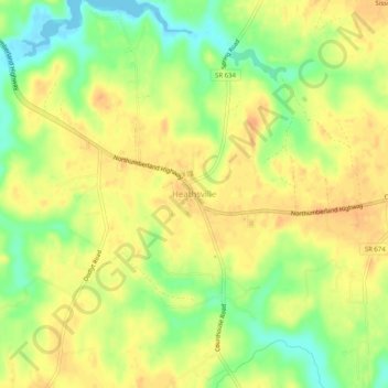
Naam: Topografische kaart Heathsville, hoogte, reliëf.
Locatie: Heathsville, Northumberland County, Virginia, United States (37.89763 -76.49217 37.93763 -76.45217)
Gemiddelde hoogte: 23 m
Minimale hoogte: -2 m
Maximale hoogte: 37 m
Andere topografische kaarten
Klik op een kaart om zijn topografie, zijn hoogte en zijn reliëf te bekijken.
Crank Island
United States > Virginia > Northumberland County
Crank Island, Northumberland County, Virginia, United States
Gemiddelde hoogte: 8 m
Remo
United States > Virginia > Northumberland County
Remo, Northumberland County, Virginia, 22579, United States
Gemiddelde hoogte: 15 m
Bamboo Island
United States > Virginia > Northumberland County
Bamboo Island, Northumberland County, Virginia, United States
Gemiddelde hoogte: 1 m
Reedville
United States > Virginia > Northumberland County > Reedville
Reedville, Northumberland County, Virginia, 22539, United States
Gemiddelde hoogte: 3 m
Sunnybank
United States > Virginia > Northumberland County > Sunnybank
Sunnybank, Northumberland County, Virginia, 22530, United States
Gemiddelde hoogte: 3 m