
Doe een donatie
Rust jezelf uit voor je volgende avontuur:
Als Amazon-partner verdient deze site een commissie op in aanmerking komende aankopen, zonder extra kosten voor jou.
Topografische kaart Namib
Klik op de kaart om de hoogte weer te geven.
Doe een donatie
Rust jezelf uit voor je volgende avontuur:
Als Amazon-partner verdient deze site een commissie op in aanmerking komende aankopen, zonder extra kosten voor jou.
Namib
The Namib (/ˈnɑːmɪb/ NAH-mib; Portuguese: Namibe) is a coastal desert in Southern Africa. According to the broadest definition, the Namib stretches for more than 2,000 kilometres (1,200 mi) along the Atlantic coasts of Angola, Namibia, and northwest South Africa, extending southward from the Carunjamba River in Angola, through Namibia and to the Olifants River in Western Cape, South Africa. The Namib's northernmost portion, which extends 450 kilometres (280 mi) from the Angola-Namibia border, is known as Moçâmedes Desert, while its southern portion approaches the neighboring Kalahari Desert. From the Atlantic coast eastward, the Namib gradually ascends in elevation, reaching up to 200 kilometres (120 mi) inland to the foot of the Great Escarpment. Annual precipitation ranges from 2 millimetres (0.079 in) in the aridest regions to 200 millimetres (7.9 in) at the escarpment, making the Namib the only true desert in southern Africa. Having endured arid or semi-arid conditions for roughly 55–80 million years, the Namib may be the oldest desert in the world and contains some of the world's driest regions, with only western South America's Atacama Desert to challenge it for age and aridity benchmarks.
Doe een donatie
Rust jezelf uit voor je volgende avontuur:
Als Amazon-partner verdient deze site een commissie op in aanmerking komende aankopen, zonder extra kosten voor jou.
Over deze kaart
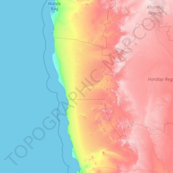
Naam: Topografische kaart Namib, hoogte, reliëf.
Locatie: Namib, Namibia (-26.70210 14.43302 -22.68153 16.45786)
Gemiddelde hoogte: 672 m
Minimale hoogte: 0 m
Maximale hoogte: 2.311 m
Doe een donatie
Rust jezelf uit voor je volgende avontuur:
Als Amazon-partner verdient deze site een commissie op in aanmerking komende aankopen, zonder extra kosten voor jou.
Andere topografische kaarten
Klik op een kaart om zijn topografie, zijn hoogte en zijn reliëf te bekijken.
Doe een donatie
Rust jezelf uit voor je volgende avontuur:
Als Amazon-partner verdient deze site een commissie op in aanmerking komende aankopen, zonder extra kosten voor jou.