
Topografische kaart Washtenaw County
Interactieve kaart
Klik op de kaart om de hoogte weer te geven.
Over deze kaart
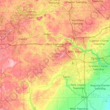
Naam: Topografische kaart Washtenaw County, hoogte, reliëf.
Locatie: Washtenaw County, Michigan, United States of America (42.07158 -84.13408 42.43518 -83.53940)
Gemiddelde hoogte: 267 m
Minimale hoogte: 194 m
Maximale hoogte: 344 m
Andere topografische kaarten
Klik op een kaart om zijn topografie, zijn hoogte en zijn reliëf te bekijken.
Van Buren County
United States of America > Michigan
Hamilton Township, Van Buren County, Michigan, United States of America
Gemiddelde hoogte: 237 m
Lake Saint Clair
United States of America > Michigan
Lake Saint Clair, Macomb County, Michigan, United States of America
Gemiddelde hoogte: 177 m
Genesee County
United States of America > Michigan
Genesee County, Michigan, United States of America
Gemiddelde hoogte: 246 m
Mackinac County
United States of America > Michigan
Mackinac County, Michigan, United States of America
Gemiddelde hoogte: 206 m
Isabella County
United States of America > Michigan
Isabella County, Michigan, United States of America
Gemiddelde hoogte: 261 m
Ann Arbor
United States of America > Michigan > Ann Arbor
Ann Arbor, Washtenaw County, Michigan, United States of America
Gemiddelde hoogte: 268 m
Portage
United States of America > Michigan > Portage
Portage, Kalamazoo County, Michigan, United States of America
Gemiddelde hoogte: 266 m
Baraga County
United States of America > Michigan
Baraga County, Michigan, United States of America
Gemiddelde hoogte: 378 m
Ontonagon County
United States of America > Michigan
Ontonagon County, Michigan, United States of America
Gemiddelde hoogte: 334 m
Sanilac County
United States of America > Michigan
Sanilac County, Michigan, United States of America
Gemiddelde hoogte: 228 m