
Topografische kaart Highlands
Interactieve kaart
Klik op de kaart om de hoogte weer te geven.
Over deze kaart
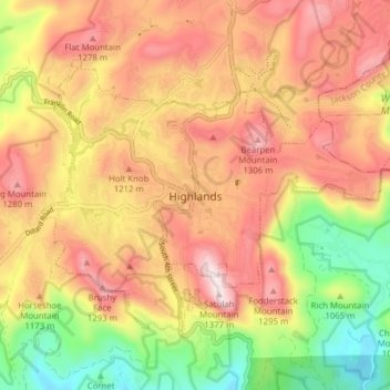
Naam: Topografische kaart Highlands, hoogte, reliëf.
Gemiddelde hoogte: 1.116 m
Minimale hoogte: 820 m
Maximale hoogte: 1.360 m
Highlands was founded in 1875 after its two founders, Samuel Truman Kelsey and Clinton Carter Hutchinson, drew lines from Chicago to Savannah and from New Orleans to New York City. They felt that the place where these lines met would eventually become a great trading center and commercial crossroads. Highlands was named for its lofty elevation.
Andere topografische kaarten
Klik op een kaart om zijn topografie, zijn hoogte en zijn reliëf te bekijken.
Franklin
United States > North Carolina > Macon County
Franklin, Macon County, North Carolina, 28734, United States
Gemiddelde hoogte: 675 m
Cedar Cliff Mountain
United States > North Carolina > Macon County
Cedar Cliff Mountain, Macon County, North Carolina, 28763, United States
Gemiddelde hoogte: 725 m
Nantahala National Forest
United States > North Carolina > Macon County
Nantahala National Forest, Macon County, East Tennessee, North Carolina, United States
Gemiddelde hoogte: 781 m
McDowell Mountain
United States > North Carolina > Macon County
McDowell Mountain, Macon County, North Carolina, 28763, United States
Gemiddelde hoogte: 714 m
Harris Lake
United States > North Carolina > Macon County > Highlands
Harris Lake, Highlands, Macon County, North Carolina, United States
Gemiddelde hoogte: 1.191 m
Duck Mountain
United States > North Carolina > Macon County
Duck Mountain, Macon County, North Carolina, 22874, United States
Gemiddelde hoogte: 1.150 m
Ellijay
United States > North Carolina > Macon County
Ellijay, Macon County, North Carolina, United States
Gemiddelde hoogte: 887 m
Teresita
United States > North Carolina > Macon County
Teresita, Macon County, North Carolina, United States
Gemiddelde hoogte: 823 m
Parrish Gap
United States > North Carolina > Macon County
Parrish Gap, Macon County, North Carolina, United States
Gemiddelde hoogte: 694 m
Little Tennessee River
United States > North Carolina > Macon County > Franklin > East Franklin
Little Tennessee River, East Franklin, Franklin, Macon County, North Carolina, 28734, United States
Gemiddelde hoogte: 641 m
Scaly Mountain
United States > North Carolina > Macon County
Scaly Mountain, Macon County, North Carolina, 28775, United States
Gemiddelde hoogte: 1.071 m
Highlands
United States > North Carolina > Macon County > Highlands
Highlands, Macon County, North Carolina, 28741, United States
Gemiddelde hoogte: 1.090 m
Otto
United States > North Carolina > Macon County
Otto, Macon County, North Carolina, 28763, United States
Gemiddelde hoogte: 676 m
Cowee
United States > North Carolina > Macon County
Cowee, Macon County, North Carolina, United States
Gemiddelde hoogte: 646 m
Fairview
United States > North Carolina > Macon County
Fairview, Macon County, North Carolina, United States
Gemiddelde hoogte: 992 m
Dean
United States > North Carolina > Macon County
Dean, Macon County, North Carolina, 28734, United States
Gemiddelde hoogte: 652 m
Aquone
United States > North Carolina > Macon County
Aquone, Macon County, North Carolina, 28781, United States
Gemiddelde hoogte: 1.088 m
Orlando
United States > North Carolina > Macon County > Orlando
Orlando, Macon County, North Carolina, 30537, United States
Gemiddelde hoogte: 725 m
Franklin
United States > North Carolina > Macon County > Franklin
Franklin, Macon County, North Carolina, 28734, United States
Gemiddelde hoogte: 665 m
Rainbow Springs
United States > North Carolina > Macon County
Rainbow Springs, Macon County, North Carolina, United States
Gemiddelde hoogte: 1.135 m