
Topografische kaart Carrollton
Interactieve kaart
Klik op de kaart om de hoogte weer te geven.
Over deze kaart
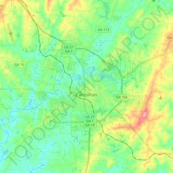
Naam: Topografische kaart Carrollton, hoogte, reliëf.
Locatie: Carrollton, Carroll County, Georgia, United States (33.53979 -85.18621 33.63340 -85.01439)
Gemiddelde hoogte: 329 m
Minimale hoogte: 287 m
Maximale hoogte: 424 m
Andere topografische kaarten
Klik op een kaart om zijn topografie, zijn hoogte en zijn reliëf te bekijken.
Mount Zion
United States > Georgia > Carroll County
Mount Zion, Carroll County, Georgia, United States
Gemiddelde hoogte: 356 m
Villa Rica
United States > Georgia > Carroll County
Villa Rica, Carroll County, Georgia, 30180, United States
Gemiddelde hoogte: 338 m
Bowdon
United States > Georgia > Carroll County
Bowdon, Carroll County, Georgia, 30108, United States
Gemiddelde hoogte: 319 m