
Topografische kaart Buffalo Gap
Interactieve kaart
Klik op de kaart om de hoogte weer te geven.
Over deze kaart
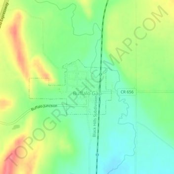
Naam: Topografische kaart Buffalo Gap, hoogte, reliëf.
Gemiddelde hoogte: 1.005 m
Minimale hoogte: 976 m
Maximale hoogte: 1.047 m
Andere topografische kaarten
Klik op een kaart om zijn topografie, zijn hoogte en zijn reliëf te bekijken.
Custer State Park
United States > South Dakota > Custer County
Custer State Park, Custer County, South Dakota, United States
Gemiddelde hoogte: 1.413 m
Stockade Lake
United States > South Dakota > Custer County
Stockade Lake, Custer County, South Dakota, United States
Gemiddelde hoogte: 1.616 m
Hermosa
United States > South Dakota > Custer County
Hermosa, Custer County, South Dakota, United States
Gemiddelde hoogte: 1.010 m
Spokane
United States > South Dakota > Custer County
Spokane, Custer County, South Dakota, United States
Gemiddelde hoogte: 1.394 m
Fourmile
United States > South Dakota > Custer County
Fourmile, Custer County, South Dakota, United States
Gemiddelde hoogte: 1.669 m
Sylvan Lake Resort
United States > South Dakota > Custer County
Sylvan Lake Resort, Custer County, South Dakota, United States
Gemiddelde hoogte: 1.889 m
State Game Lodge
United States > South Dakota > Custer County
State Game Lodge, Custer County, South Dakota, United States
Gemiddelde hoogte: 1.348 m
Berne
United States > South Dakota > Custer County
Berne, Custer County, South Dakota, United States
Gemiddelde hoogte: 1.799 m
Wind Cave National Park
United States > South Dakota > Custer County
Wind Cave National Park, Custer County, South Dakota, United States
Gemiddelde hoogte: 1.315 m