
Topografische kaart Casteljau
Interactieve kaart
Klik op de kaart om de hoogte weer te geven.
Over deze kaart
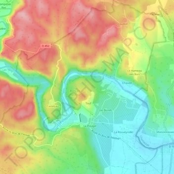
Naam: Topografische kaart Casteljau, hoogte, reliëf.
Gemiddelde hoogte: 180 m
Minimale hoogte: 108 m
Maximale hoogte: 262 m
Andere topografische kaarten
Klik op een kaart om zijn topografie, zijn hoogte en zijn reliëf te bekijken.
Mazet
France > Auvergne-Rhône-Alpes > Ardèche > Berrias-et-Casteljau
Mazet, Casteljau, Berrias-et-Casteljau, Largentière, Ardèche, Auvergne-Rhône-Alpes, France métropolitaine, 07460, France
Gemiddelde hoogte: 171 m
Le Hameau des Buis
France > Auvergne-Rhône-Alpes > Ardèche > Berrias-et-Casteljau
Le Hameau des Buis, Casteljau, Berrias-et-Casteljau, Largentière, Ardèche, Auvergne-Rhône-Alpes, France métropolitaine, 07460, France
Gemiddelde hoogte: 170 m
Grotte de la Tardive
France > Auvergne-Rhône-Alpes > Ardèche > Berrias-et-Casteljau > Casteljau
Grotte de la Tardive, La Presqu'Île, Casteljau, Berrias-et-Casteljau, Largentière, Ardèche, Auvergne-Rhône-Alpes, France métropolitaine, 07460, France
Gemiddelde hoogte: 178 m
Le Pouget
France > Auvergne-Rhône-Alpes > Ardèche > Berrias-et-Casteljau
Le Pouget, Casteljau, Berrias-et-Casteljau, Largentière, Ardèche, Auvergne-Rhône-Alpes, France métropolitaine, 07460, France
Gemiddelde hoogte: 162 m
Les Borels
France > Auvergne-Rhône-Alpes > Ardèche > Berrias-et-Casteljau
Les Borels, Casteljau, Berrias-et-Casteljau, Largentière, Ardèche, Auvergne-Rhône-Alpes, France métropolitaine, 07460, France
Gemiddelde hoogte: 164 m
Berrias
France > Auvergne-Rhône-Alpes > Ardèche > Berrias-et-Casteljau
Berrias, Berrias-et-Casteljau, Largentière, Ardèche, Auvergne-Rhône-Alpes, France métropolitaine, 07460, France
Gemiddelde hoogte: 174 m