
Topografische kaart Voyageur Provincial Park
Interactieve kaart
Klik op de kaart om de hoogte weer te geven.
Over deze kaart
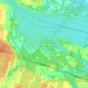
Naam: Topografische kaart Voyageur Provincial Park, hoogte, reliëf.
Gemiddelde hoogte: 46 m
Minimale hoogte: 33 m
Maximale hoogte: 71 m
Andere topografische kaarten
Klik op een kaart om zijn topografie, zijn hoogte en zijn reliëf te bekijken.
Chute-à-Blondeau
Canada > Ontario > Prescott and Russell Counties > East Hawkesbury
Gemiddelde hoogte: 56 m