
Topografische kaart Le Frontal
Interactieve kaart
Klik op de kaart om de hoogte weer te geven.
Over deze kaart
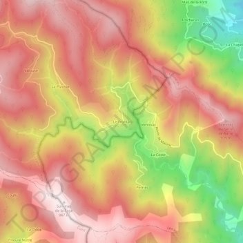
Naam: Topografische kaart Le Frontal, hoogte, reliëf.
Gemiddelde hoogte: 663 m
Minimale hoogte: 202 m
Maximale hoogte: 941 m
Andere topografische kaarten
Klik op een kaart om zijn topografie, zijn hoogte en zijn reliëf te bekijken.
Cessénades
France > Occitanie > Gard > Malons-et-Elze
Cessénades, Malons-et-Elze, Alès, Gard, Occitanie, France métropolitaine, 30450, France
Gemiddelde hoogte: 788 m