
Topografische kaart Valencia
Interactieve kaart
Klik op de kaart om de hoogte weer te geven.
Valencia
The city's topography is characterized as flat to undulating hills with extensive plateaus and mountainous areas and cliffs on both eastern and western portions bounding the municipality of San Fernando on the east and the municipality of Talakag on the west. Its highest point is Mount Kalatungan in the Kalatungan Mountain Range rising above 1,000 meters and above 50 percent slopes. These cover 25.72 percent of the total city area and major portions of Barangay of Lourdes, Guinoyuran and Lilingayon.
Over deze kaart
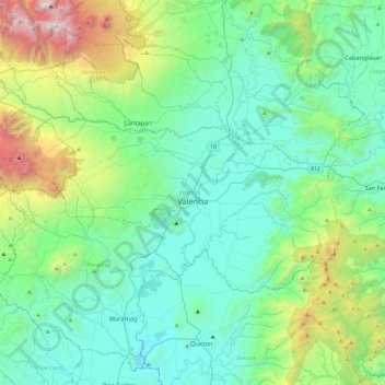
Naam: Topografische kaart Valencia, hoogte, reliëf.
Locatie: Valencia, Bukidnon, Northern Mindanao, 8709, Philippines (7.79163 124.80269 8.03586 125.27332)
Gemiddelde hoogte: 736 m
Minimale hoogte: 182 m
Maximale hoogte: 2.878 m
Andere topografische kaarten
Klik op een kaart om zijn topografie, zijn hoogte en zijn reliëf te bekijken.