
Topografische kaart Biliran
Interactieve kaart
Klik op de kaart om de hoogte weer te geven.
Over deze kaart
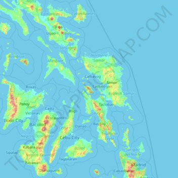
Naam: Topografische kaart Biliran, hoogte, reliëf.
Locatie: Biliran, Eastern Visayas, Philippines (9.00000 121.89000 14.20000 127.09000)
Gemiddelde hoogte: 48 m
Minimale hoogte: -2 m
Maximale hoogte: 2.388 m
Andere topografische kaarten
Klik op een kaart om zijn topografie, zijn hoogte en zijn reliëf te bekijken.
Baguio
Baguio, Cordillera Administrative Region, 2600, Philippines
Gemiddelde hoogte: 1.371 m
Northern Manila District
Northern Manila District, Métro Manile, Philippines
Gemiddelde hoogte: 22 m
Laoag
Laoag, Ilocos Norte, Ilocos Region, 2900, Philippines
Gemiddelde hoogte: 48 m
Santa Fe
Philippines > Sorsogon > Pilar
Santa Fe, Pilar, Sorsogon, Bicol Region, 3202, Philippines
Gemiddelde hoogte: 13 m
Dumaguete
Dumaguete, Negros oriental, Central Visayas, 6200, Philippines
Gemiddelde hoogte: 55 m
Patag
Philippines > Leyte > Baybay
Patag, Baybay, Leyte 5th District, Leyte, Eastern Visayas, 6521, Philippines
Gemiddelde hoogte: 64 m
San Juan
San Juan, Batangas, Calabarzon, 4226, Philippines
Gemiddelde hoogte: 60 m
Manille
Manille, Fifth District, Manila, Grand Manille, Philippines
Gemiddelde hoogte: 6 m
Philippine Relief Map
Philippine Relief Map, Ermita, Fifth District, Manille, Capital District, Grand Manille, 1000, Philippines
Gemiddelde hoogte: 7 m
Zone 18
Zone 18, District 2, Pasay, Southern Manila District, Grand Manille, Philippines
Gemiddelde hoogte: 9 m
Caloocan
Caloocan, Northern Manila District, Grand Manille, Philippines
Gemiddelde hoogte: 18 m
Lias
Philippines > Bulacan > Marilao > Lias
Lias, Marilao, Bulacan, Central Luzon, 3019, Philippines
Gemiddelde hoogte: 9 m
Tigaon
Philippines > Camarines Sur > Tigaon
Tigaon, Camarines Sur, Bicol Region, 4420, Philippines
Gemiddelde hoogte: 70 m
North Cotabato
North Cotabato, Soccsksargen, Philippines
Gemiddelde hoogte: 387 m
Coline
Philippines > Iloilo > Coline
Coline, Iloilo, Western Visayas, 5025, Philippines
Gemiddelde hoogte: 54 m
Las Piñas
Las Piñas, Southern Manila District, Grand Manille, Philippines
Gemiddelde hoogte: 24 m
Nasugbu
Nasugbu, Batangas, Calabarzon, 4231, Philippines
Gemiddelde hoogte: 71 m
Taal
Philippines > Batangas > Taal
Taal, Batangas, Calabarzon, 4208, Philippines
Gemiddelde hoogte: 44 m
Mantalongon
Philippines > Cebu > Mantalongon
Mantalongon, Cebu, Central Visayas, Philippines
Gemiddelde hoogte: 194 m
Leyte du Sud
Leyte du Sud, Eastern Visayas, Philippines
Gemiddelde hoogte: 66 m
Bontoc
Philippines > Mountain Province > Bontoc
Bontoc, Mountain Province, 2616, Philippines
Gemiddelde hoogte: 1.143 m
Manhilo
Philippines > Leyte du Sud > Manhilo
Manhilo, Leyte du Sud, Eastern Visayas, 6600, Philippines
Gemiddelde hoogte: 21 m
Mambajao
Mambajao, Camiguin, Northern Mindanao, 9100, Philippines
Gemiddelde hoogte: 51 m
Quezon City
Quezon City, Eastern Manila District, Métro Manile, 1100, Philippines
Gemiddelde hoogte: 39 m
Botolan
Philippines > Zambales > Botolan
Botolan, Zambales, Central Luzon, 2202, Philippines
Gemiddelde hoogte: 22 m
Morong
Philippines > Rizal > Morong
Morong, Rizal, Calabarzon, 1960, Philippines
Gemiddelde hoogte: 37 m
Zone 10
Zone 10, District 1, Pasay, Fourth District, Grand Manille, Philippines
Gemiddelde hoogte: 5 m