

Topografische kaart Bokaro
Klik op de kaart om de hoogte weer te geven.
Bokaro
Bokaro district consists of undulating uplands on the Chota Nagpur Plateau with the Damodar River cutting a valley right across. It has an average elevation of 200 to 540 metres (660 to 1,770 ft) above mean sea level. The highest hill, Lugu Pahar, rises to a height of 1,070 metres (3,510 ft). The East Bokaro Coalfield located in the Bermo-Phusro area and small intrusions of Jharia Coalfield make Bokaro a coal rich district. In 1965, one of the largest steel manufacturing units in the country, Bokaro Steel Plant, operated by Steel Authority of India Limited, was set-up at Bokaro Steel City. The Damodar Valley Corporation established its first thermal power station at Bokaro (Thermal). The 5 kilometres (3.1 mi) long, 55 metres (180 ft) high earthfill dam with composite masonry cum concrete spillway, Tenughat Dam, across the Damodar River, is operated by the Government of Jharkhand. The average annual rainfall is 1,291.2 millimetres (50.83 in). The soil is generally infertile and agriculture is mostly rain-fed.
Over deze kaart
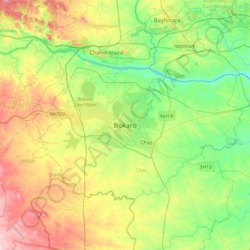
Naam: Topografische kaart Bokaro, hoogte, reliëf.
Locatie: Bokaro, Chas, Bokaro District, Jharkhand, 827004, India (23.49443 85.98564 23.81443 86.30564)
Gemiddelde hoogte: 232 m
Minimale hoogte: 139 m
Maximale hoogte: 388 m