
Topografische kaart Kew
Klik op de kaart om de hoogte weer te geven.
Over deze kaart
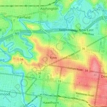
Naam: Topografische kaart Kew, hoogte, reliëf.
Locatie: Kew, Melbourne, Victoria, 3101, Australia (-37.81736 144.99926 -37.78557 145.06253)
Gemiddelde hoogte: 38 m
Minimale hoogte: 6 m
Maximale hoogte: 88 m
Andere topografische kaarten
Klik op een kaart om zijn topografie, zijn hoogte en zijn reliëf te bekijken.
Narre Warren North Retarding Basin (Melbourne Water)
Australia > Victoria > Melbourne
Gemiddelde hoogte: 76 m
Mount Dandenong
Australia > Victoria > Melbourne
Mount Dandenong has a cool oceanic climate (Cfb), with cool to mild summers and cold, damp winters. Daytime temperatures are usually 4−6 °C cooler than downtown Melbourne due to its elevation and distance from the urban heat island effect of Melbourne. It is significantly cloudier than Melbourne,…
Gemiddelde hoogte: 395 m
Gilbertsons Grassland Nature Conservation Reserve
Australia > Victoria > Melbourne
Gemiddelde hoogte: 36 m
Yarra Valley
Australia > Victoria > Melbourne
The Yarra Valley is the region surrounding the Yarra River in Victoria, Australia. The river originates approximately 240 km (150 mi) east of the Melbourne central business district and flows towards it and out into Port Phillip Bay. The name Yarra Valley is used in reference to the upper regions surrounding…
Gemiddelde hoogte: 305 m
Langwarrin Flora and Fauna Reserve
Australia > Victoria > Melbourne > Langwarrin
Gemiddelde hoogte: 90 m