
Topografische kaart Wolcott
Interactieve kaart
Klik op de kaart om de hoogte weer te geven.
Wolcott
The highest point in New Haven County is found in Wolcott atop Lindsley Hill, which has an elevation of approximately 1,046 feet above sea level.
Over deze kaart
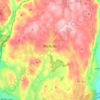
Naam: Topografische kaart Wolcott, hoogte, reliëf.
Gemiddelde hoogte: 209 m
Minimale hoogte: 56 m
Maximale hoogte: 320 m
Andere topografische kaarten
Klik op een kaart om zijn topografie, zijn hoogte en zijn reliëf te bekijken.
Sunnyside
United States > Connecticut > Naugatuck Valley Planning Region > Shelton
Gemiddelde hoogte: 54 m
Hillcrest
United States > Connecticut > Naugatuck Valley Planning Region > Middlebury
Gemiddelde hoogte: 177 m
Lake Plymouth Dam
United States > Connecticut > Naugatuck Valley Planning Region > Plymouth
Gemiddelde hoogte: 211 m
Kettletown
United States > Connecticut > Naugatuck Valley Planning Region > Southbury
Gemiddelde hoogte: 150 m
Straitsville
United States > Connecticut > Naugatuck Valley Planning Region > Naugatuck
Gemiddelde hoogte: 146 m
Oakdale Manor
United States > Connecticut > Naugatuck Valley Planning Region > Southbury
Gemiddelde hoogte: 85 m
Lakewood
United States > Connecticut > Naugatuck Valley Planning Region > Waterbury
Gemiddelde hoogte: 165 m
Millville
United States > Connecticut > Naugatuck Valley Planning Region > Naugatuck
Gemiddelde hoogte: 132 m
Edgewood
United States > Connecticut > Naugatuck Valley Planning Region > Bristol
Gemiddelde hoogte: 104 m
Glen Ridge
United States > Connecticut > Naugatuck Valley Planning Region > Naugatuck
Gemiddelde hoogte: 119 m
Forestville
United States > Connecticut > Naugatuck Valley Planning Region > Bristol
Gemiddelde hoogte: 99 m