
Topografische kaart Pristina
Interactieve kaart
Klik op de kaart om de hoogte weer te geven.
Pristina
By the early Iron Age, the distinctly Dardanian local variant of the Illyrian Glasinac-Mati culture appears in Kosovo with a particular spread in hilltop settlements. In the area of Pristina, a hilltop settlement appears since the 8th century BCE at an altitude of 685m near the village Teneshdoll, ~16 km to the north of the Pristina city center. Pottery finds suggests that the area may have been in use since the Bronze Age. The settlement seems to have maintained long-distance trade contacts as the finding of a skyphos vessel from Aegean Greece suggests. During the 4th century BC, a Dardanian Kingdom was established in the region. Following the Roman conquest of Illyria in 168 BC, Romans colonized and founded several cities in the region.
Over deze kaart
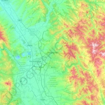
Naam: Topografische kaart Pristina, hoogte, reliëf.
Locatie: Pristina, Municipality of Pristina, 10000, Kosovo (42.50388 21.00408 42.82388 21.32408)
Gemiddelde hoogte: 695 m
Minimale hoogte: 480 m
Maximale hoogte: 1.226 m
Andere topografische kaarten
Klik op een kaart om zijn topografie, zijn hoogte en zijn reliëf te bekijken.