
Doe een donatie
Rust jezelf uit voor je volgende avontuur:
Als Amazon-partner verdient deze site een commissie op in aanmerking komende aankopen, zonder extra kosten voor jou.
Topografische kaart County Limerick
Klik op de kaart om de hoogte weer te geven.
Doe een donatie
Rust jezelf uit voor je volgende avontuur:
Als Amazon-partner verdient deze site een commissie op in aanmerking komende aankopen, zonder extra kosten voor jou.
County Limerick
One possible meaning for the county's name in Irish Luimneach is "the flat area"; this description is accurate as the land consists mostly of a fertile limestone plain. Moreover, the county is ringed by mountains: the Slieve Felims to the northeast, the Galtees to the southeast, the Ballyhoura Mountains to the south, and the Mullaghareirk Mountains to the southwest and west. The highest point in the county is located in its southeast corner at Galtymore (919 m), which separates Limerick from County Tipperary. Limerick shares the 3rd-highest county peak in Ireland with Tipperary. The county is not simply a plain, its topography consists of hills and ridges. The eastern part of the county is part of the Golden Vale, which is well known for dairy produce and consists of rolling low hills. This gives way to very flat land around the centre of the county, with the exception being Knockfierna at 288 m high. Towards the west, the Mullaghareirk Mountains (Mullach an Radhairc in Irish, roughly meaning "mountains of the view") push across the county offering extensive views east over the county and west into County Kerry.
Doe een donatie
Rust jezelf uit voor je volgende avontuur:
Als Amazon-partner verdient deze site een commissie op in aanmerking komende aankopen, zonder extra kosten voor jou.
Over deze kaart
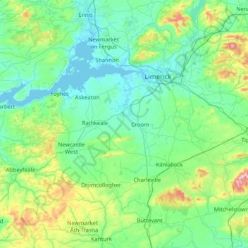
Naam: Topografische kaart County Limerick, hoogte, reliëf.
Locatie: County Limerick, Munster, Ireland (52.28020 -9.36543 52.75738 -8.15637)
Gemiddelde hoogte: 110 m
Minimale hoogte: -1 m
Maximale hoogte: 811 m
Doe een donatie
Rust jezelf uit voor je volgende avontuur:
Als Amazon-partner verdient deze site een commissie op in aanmerking komende aankopen, zonder extra kosten voor jou.
Andere topografische kaarten
Klik op een kaart om zijn topografie, zijn hoogte en zijn reliëf te bekijken.
Kilcruaig
Ireland > County Limerick > The Municipal District of Cappamore — Kilmallock
Gemiddelde hoogte: 200 m
Knockadea
Ireland > County Limerick > The Municipal District of Cappamore — Kilmallock
Gemiddelde hoogte: 203 m
Pallasgreen
Ireland > County Limerick > The Municipal District of Cappamore — Kilmallock
Gemiddelde hoogte: 72 m
Galtymore
Ireland > County Limerick > The Municipal District of Cappamore — Kilmallock
Galtymore or Galteemore (Irish: Cnoc Mór na nGaibhlte, meaning 'big hill of the Galtees') is a mountain in the province of Munster, Ireland. At 917.9 metres (3,011 ft 6 in), it is one of Ireland's highest mountains, being the 12th-highest on the Arderin list, and 14th-highest on the Vandeleur-Lynam list.…
Gemiddelde hoogte: 594 m
Doe een donatie
Rust jezelf uit voor je volgende avontuur:
Als Amazon-partner verdient deze site een commissie op in aanmerking komende aankopen, zonder extra kosten voor jou.
Aherlow
Ireland > County Limerick > The Municipal District of Cappamore — Kilmallock
Gemiddelde hoogte: 141 m
Clare Glens
Ireland > County Limerick > The Municipal District of Cappamore — Kilmallock
Gemiddelde hoogte: 124 m
Knockawarriga
Ireland > County Limerick > The Municipal District of Newcastle West
Gemiddelde hoogte: 247 m
Doe een donatie
Rust jezelf uit voor je volgende avontuur:
Als Amazon-partner verdient deze site een commissie op in aanmerking komende aankopen, zonder extra kosten voor jou.
Crecora
Ireland > County Limerick > The Municipal District of Adare — Rathkeale
Gemiddelde hoogte: 37 m
Bleach Lough
Ireland > County Limerick > The Municipal District of Adare — Rathkeale
Gemiddelde hoogte: 10 m
Ardpatrick
Ireland > County Limerick > The Municipal District of Cappamore — Kilmallock
Gemiddelde hoogte: 169 m
Templeglantine
Ireland > County Limerick > The Municipal District of Newcastle West
Gemiddelde hoogte: 189 m
Doe een donatie
Rust jezelf uit voor je volgende avontuur:
Als Amazon-partner verdient deze site een commissie op in aanmerking komende aankopen, zonder extra kosten voor jou.
Bruff
Ireland > County Limerick > The Municipal District of Cappamore — Kilmallock
Gemiddelde hoogte: 68 m
Bruree
Ireland > County Limerick > The Municipal District of Cappamore — Kilmallock
Gemiddelde hoogte: 62 m
Doe een donatie
Rust jezelf uit voor je volgende avontuur:
Als Amazon-partner verdient deze site een commissie op in aanmerking komende aankopen, zonder extra kosten voor jou.
Croom
Ireland > County Limerick > The Municipal District of Adare — Rathkeale > Croom
Gemiddelde hoogte: 34 m
Limerick
Ireland > County Limerick > Limerick
Limerick's climate is classified as temperate oceanic (Köppen Cfb). Met Éireann maintains a climatological weather station at Shannon Airport, 20 kilometres west of the city in County Clare. Shannon Airport records an average of 977 millimetres of precipitation annually, most of which is rain. Limerick has a…
Gemiddelde hoogte: 10 m
Doe een donatie
Rust jezelf uit voor je volgende avontuur:
Als Amazon-partner verdient deze site een commissie op in aanmerking komende aankopen, zonder extra kosten voor jou.
Tory Hill
Ireland > County Limerick > The Municipal District of Adare — Rathkeale
Gemiddelde hoogte: 35 m
Doe een donatie
Rust jezelf uit voor je volgende avontuur:
Als Amazon-partner verdient deze site een commissie op in aanmerking komende aankopen, zonder extra kosten voor jou.