Geolokaliseren

Topografische kaart Columbus

Klik op de kaart om de hoogte weer te geven.

👉 Easily get elevation data in JSON, GeoTIFF and KML formats using Elevation API
Bedankt voor het steunen van deze site ❤️
Doe een donatie

Rust jezelf uit voor je volgende avontuur:

Als Amazon-partner verdient deze site een commissie op in aanmerking komende aankopen, zonder extra kosten voor jou.

Columbus

The confluence of the Scioto and Olentangy rivers is just north-west of Downtown Columbus. Several smaller tributaries course through the Columbus metropolitan area, including Alum Creek, Big Walnut Creek, and Darby Creek. Columbus is considered to have relatively flat topography thanks to a large glacier that covered most of Ohio during the Wisconsin Ice Age. However, there are sizable differences in elevation through the area, with the high point of Franklin County being 1,132 ft (345 m) above sea level near New Albany, and the low point being 670 ft (200 m) where the Scioto River leaves the county near Lockbourne. Numerous ravines near the rivers and creeks also add variety to the landscape. Tributaries to Alum Creek and the Olentangy River cut through shale, while tributaries to the Scioto River cut through limestone.

👉 Easily get elevation data in JSON, GeoTIFF and KML formats using Elevation API
Bedankt voor het steunen van deze site ❤️
Doe een donatie

Rust jezelf uit voor je volgende avontuur:

Als Amazon-partner verdient deze site een commissie op in aanmerking komende aankopen, zonder extra kosten voor jou.

Over deze kaart

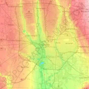
Naam: Topografische kaart Columbus, hoogte, reliëf.

Locatie: Columbus, Franklin County, Ohio, 43216, United States (39.80226 -83.16071 40.12226 -82.84071)

Gemiddelde hoogte: 255 m

Minimale hoogte: 169 m

Maximale hoogte: 333 m

👉 Easily get elevation data in JSON, GeoTIFF and KML formats using Elevation API
Bedankt voor het steunen van deze site ❤️
Doe een donatie

Rust jezelf uit voor je volgende avontuur:

Als Amazon-partner verdient deze site een commissie op in aanmerking komende aankopen, zonder extra kosten voor jou.

Andere topografische kaarten

Klik op een kaart om zijn topografie, zijn hoogte en zijn reliëf te bekijken.

Wrexham Park

United States > Ohio > Franklin County > Columbus

Gemiddelde hoogte: 234 m

Rust jezelf uit voor je volgende avontuur:

🐕Hondenharnassen - Neem je hond mee op je topografische avonturen
マットSlaapmatjes - Comfortabel slapen na een dag klimmen en dalen
🎒Hydratatiezakken - Handige wateroplossing tijdens hikes
🍲Outdoor Voeding - Lichtgewicht maaltijden voor wandeltochten
🔥Campingbranders - Bereid je koffie of maaltijd waar je ook bent

Als Amazon-partner verdient deze site een commissie op in aanmerking komende aankopen, zonder extra kosten voor jou.