
Topografische kaart Hilda
Interactieve kaart
Klik op de kaart om de hoogte weer te geven.
Over deze kaart
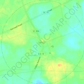
Naam: Topografische kaart Hilda, hoogte, reliëf.
Locatie: Hilda, Barnwell County, South Carolina, 29813, United States (33.25959 -81.26376 33.28844 -81.22936)
Gemiddelde hoogte: 78 m
Minimale hoogte: 65 m
Maximale hoogte: 96 m
Andere topografische kaarten
Klik op een kaart om zijn topografie, zijn hoogte en zijn reliëf te bekijken.
Barnwell
United States > South Carolina > Barnwell County
Barnwell, Barnwell County, South Carolina, 29812, United States
Gemiddelde hoogte: 64 m
Elko
United States > South Carolina > Barnwell County
Elko, Barnwell County, South Carolina, United States
Gemiddelde hoogte: 99 m
Barnwell State Park
United States > South Carolina > Barnwell County > Blackville
Barnwell State Park, Blackville, Barnwell County, South Carolina, United States
Gemiddelde hoogte: 84 m
Williston
United States > South Carolina > Barnwell County
Williston, Barnwell County, South Carolina, 29853, United States
Gemiddelde hoogte: 102 m
Blackville
United States > South Carolina > Barnwell County
Blackville, Barnwell County, South Carolina, 29817, United States
Gemiddelde hoogte: 85 m
Barnwell State Park
United States > South Carolina > Barnwell County
Barnwell State Park, Barnwell County, South Carolina, 29817, United States
Gemiddelde hoogte: 83 m
Barnwell
United States > South Carolina > Barnwell County > Barnwell
Barnwell, Barnwell County, South Carolina, 29812, United States
Gemiddelde hoogte: 65 m
Snelling
United States > South Carolina > Barnwell County
Snelling, Barnwell County, South Carolina, United States
Gemiddelde hoogte: 73 m