
Topografische kaart Cottonwood Point
Interactieve kaart
Klik op de kaart om de hoogte weer te geven.
Over deze kaart
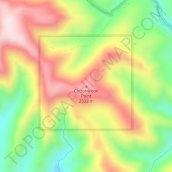
Naam: Topografische kaart Cottonwood Point, hoogte, reliëf.
Locatie: Cottonwood Point, Grand County, Utah, United States (39.15075 -109.60184 39.15085 -109.60174)
Gemiddelde hoogte: 2.346 m
Minimale hoogte: 2.118 m
Maximale hoogte: 2.576 m
Andere topografische kaarten
Klik op een kaart om zijn topografie, zijn hoogte en zijn reliëf te bekijken.
Moab
United States > Utah > Grand County
Moab, Grand County, Utah, 84532, United States
Gemiddelde hoogte: 1.357 m
Westwater
United States > Utah > Grand County
Westwater, Grand County, Utah, United States
Gemiddelde hoogte: 1.349 m
Cisco
United States > Utah > Grand County
Cisco, Grand County, Utah, 84515, United States
Gemiddelde hoogte: 1.334 m
Rectory
United States > Utah > Grand County
Rectory, Grand County, Utah, United States
Gemiddelde hoogte: 1.527 m
Delicate Arch
United States > Utah > Grand County
Delicate Arch, Delicate Arch Trail, Grand County, Utah, United States
Gemiddelde hoogte: 1.409 m
Arches National Park
United States > Utah > Grand County
Arches National Park, Grand County, Utah, United States
Gemiddelde hoogte: 1.476 m
Thompson Springs
United States > Utah > Grand County
Thompson Springs, Grand County, Utah, 84540, United States
Gemiddelde hoogte: 1.583 m
Colorado River
United States > Utah > Grand County > Moab
Colorado River, Moab, Grand County, Utah, United States
Gemiddelde hoogte: 1.668 m
Castle Valley
United States > Utah > Grand County
Castle Valley, Grand County, Utah, United States
Gemiddelde hoogte: 1.610 m
La Sal Mountains Viewpoint
United States > Utah > Grand County
La Sal Mountains Viewpoint, Main Park Road, Grand County, Utah, 84532-2134, United States
Gemiddelde hoogte: 1.347 m