
Topografische kaart Bazargan
Interactieve kaart
Klik op de kaart om de hoogte weer te geven.
Over deze kaart
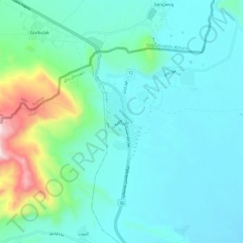
Naam: Topografische kaart Bazargan, hoogte, reliëf.
Gemiddelde hoogte: 1.507 m
Minimale hoogte: 1.366 m
Maximale hoogte: 2.189 m
Until well within the 20th century, Bazargan was not much more than a small village, located at an altitude of 1,550 meters on a delta above the Aqchay river. Bazargan's inhabitants, of Turkic origin, were generally involved in traditional agricultural activities. In 1913, the village was ceded by the Ottoman Empire to Qajar Iran. The village of Bazargan has only developed recently (and that in a limited way), due to the existence of the nearby frontier crossing with Turkey.[4]
Andere topografische kaarten
Klik op een kaart om zijn topografie, zijn hoogte en zijn reliëf te bekijken.
Malham
Iran > West Azerbaijan Province > Maku County
Malham, بخش بازرگان, Maku County, West Azerbaijan Province, Iran
Gemiddelde hoogte: 1.277 m