
Topografische kaart Wyong River
Interactieve kaart
Klik op de kaart om de hoogte weer te geven.
Over deze kaart
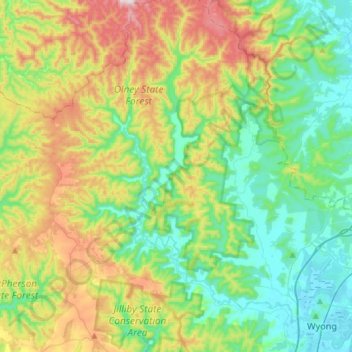
Naam: Topografische kaart Wyong River, hoogte, reliëf.
Gemiddelde hoogte: 175 m
Minimale hoogte: 0 m
Maximale hoogte: 558 m
Andere topografische kaarten
Klik op een kaart om zijn topografie, zijn hoogte en zijn reliëf te bekijken.
Kincumber
Australia > New South Wales > Gosford
Kincumber, Gosford, Central Coast Council, New South Wales, 2251, Australia
Gemiddelde hoogte: 37 m
Bateau Bay
Australia > New South Wales > Gosford
Bateau Bay, Gosford, Central Coast Council, New South Wales, 2261, Australia
Gemiddelde hoogte: 16 m
Tuggerawong
Australia > New South Wales > Gosford
Tuggerawong, Gosford, Central Coast Council, New South Wales, 2259, Australia
Gemiddelde hoogte: 3 m
Wagstaffe
Australia > New South Wales > Gosford
Wagstaffe, Gosford, Central Coast Council, New South Wales, 2257, Australia
Gemiddelde hoogte: 17 m
Lake Macquarie State Conservation Area
Australia > New South Wales > Gosford
Lake Macquarie State Conservation Area, Kanangra Drive, Crangan Bay, Gosford, Central Coast Council, New South Wales, 2259, Australia
Gemiddelde hoogte: 16 m
Mangrove Mountain
Australia > New South Wales > Gosford
Mangrove Mountain, Gosford, Central Coast Council, New South Wales, 2250, Australia
Gemiddelde hoogte: 194 m