
Topografische kaart Buzău
Interactieve kaart
Klik op de kaart om de hoogte weer te geven.
Over deze kaart
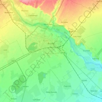
Naam: Topografische kaart Buzău, hoogte, reliëf.
Locatie: Buzău, Romania (45.09161 26.71469 45.18375 26.92587)
Gemiddelde hoogte: 96 m
Minimale hoogte: 66 m
Maximale hoogte: 152 m
The city is located in the center of the county, 100 km north-east of Bucharest, in the south-east of Romania, taking up a total area of 81,3 km2, at the outermost curvature of the Subcarpathian foothills, at the crossroads of the three main Romanian historical provinces: Wallachia, Transylvania and Moldavia. It is entirely placed on the right bank of Buzău river, which forms its northern limit. The shape of the city is oblong, longer along the river and shorter across. It reaches altitudes of 101 meters in the north-west, near the foothills, going down to 88 meters on the riverbank, while the average altitude of 95 meters is the same as the altitude of Dacia square, in the city center. Thus, Buzău is placed in a flat area, with a height difference of just 10 meters along a 4-kilometer line.
Andere topografische kaarten
Klik op een kaart om zijn topografie, zijn hoogte en zijn reliëf te bekijken.
Râmnicu Sărat
Romania > Buzău > Râmnicu Sărat
Râmnicu Sărat, Buzău, 125300, Romania
Gemiddelde hoogte: 128 m