Geolokaliseren
👉 Easily get elevation data in JSON, GeoTIFF and KML formats using Elevation API
Bedankt voor het steunen van deze site ❤️
Doe een donatie

Rust jezelf uit voor je volgende avontuur:

Als Amazon-partner verdient deze site een commissie op in aanmerking komende aankopen, zonder extra kosten voor jou.

Topografische kaart Tweed Heads

Klik op de kaart om de hoogte weer te geven.

Over deze kaart

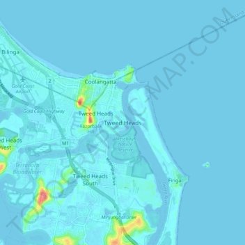
Naam: Topografische kaart Tweed Heads, hoogte, reliëf.

Locatie: Tweed Heads, Tweed Shire Council, New South Wales, 2485, Australia (-28.22171 153.50696 -28.14171 153.58696)

Gemiddelde hoogte: 3 m

Minimale hoogte: -3 m

Maximale hoogte: 74 m

Andere topografische kaarten

Klik op een kaart om zijn topografie, zijn hoogte en zijn reliëf te bekijken.

Sydney

Australia > New South Wales

Sydney's topography is characterized by a diverse landscape that seamlessly blends coastal features with inland plateaus. The city is divided into two primary regions: the relatively flat Cumberland Plain to the south and west of Sydney Harbour, and the elevated Hornsby Plateau to the north. The Cumberland…

Gemiddelde hoogte: 53 m

Newcastle

Australia > New South Wales

Gemiddelde hoogte: 5 m

Sydney CBD

Australia > New South Wales > Sydney

Gemiddelde hoogte: 25 m

Bedankt voor het steunen van deze site ❤️
Doe een donatie

Rust jezelf uit voor je volgende avontuur:

Als Amazon-partner verdient deze site een commissie op in aanmerking komende aankopen, zonder extra kosten voor jou.

Baulkham Hills

Australia > New South Wales

Gemiddelde hoogte: 93 m

Oberon Council

Australia > New South Wales

Gemiddelde hoogte: 899 m

Botany

Australia > New South Wales > Sydney

Gemiddelde hoogte: 6 m

Castlereagh River

Australia > New South Wales

The Castlereagh rises 20 km west of Coonabarabran in the heart of the Warrumbungle mountains at an elevation of about 850 metres. From its commencement upstream in the mountains the river initially flows east through the town of Coonabarabran. It then arcs round south and southwesterly to the village of…

Gemiddelde hoogte: 240 m

Bowral

Australia > New South Wales

Gemiddelde hoogte: 690 m

Castle Hill

Australia > New South Wales > Sydney

Gemiddelde hoogte: 123 m

Bunyah

Australia > New South Wales

Gemiddelde hoogte: 137 m

Modanville

Australia > New South Wales

Gemiddelde hoogte: 118 m

Penrith

Australia > New South Wales > Sydney > Penrith

Penrith is a city in New South Wales, Australia, located in Greater Western Sydney, 55 kilometres (31 mi) west of the Sydney central business district on the banks of the Nepean River, on the outskirts of the Cumberland Plain. Its elevation is 32 metres (105 ft).

Gemiddelde hoogte: 34 m

Botany Bay

Australia > New South Wales > Sydney

Gemiddelde hoogte: 8 m

Bedankt voor het steunen van deze site ❤️
Doe een donatie

Rust jezelf uit voor je volgende avontuur:

Als Amazon-partner verdient deze site een commissie op in aanmerking komende aankopen, zonder extra kosten voor jou.

Mudgee

Australia > New South Wales

Gemiddelde hoogte: 535 m

Eden

Australia > New South Wales

Gemiddelde hoogte: 55 m

North Sydney

Australia > New South Wales > Sydney

Gemiddelde hoogte: 50 m

Tumbarumba

Australia > New South Wales

Gemiddelde hoogte: 774 m

Avalon Beach

Australia > New South Wales

Gemiddelde hoogte: 24 m

Taree

Australia > New South Wales

Gemiddelde hoogte: 17 m

Cecil Hills

Australia > New South Wales

Gemiddelde hoogte: 77 m

Epping

Australia > New South Wales > Sydney

Gemiddelde hoogte: 96 m

Goonellabah

Australia > New South Wales

Gemiddelde hoogte: 86 m

Quakers Hill

Australia > New South Wales

Gemiddelde hoogte: 35 m

Bedankt voor het steunen van deze site ❤️
Doe een donatie

Rust jezelf uit voor je volgende avontuur:

Als Amazon-partner verdient deze site een commissie op in aanmerking komende aankopen, zonder extra kosten voor jou.

Byron Shire Council

Australia > New South Wales

Gemiddelde hoogte: 104 m

Tintenbar

Australia > New South Wales

Gemiddelde hoogte: 49 m

Cooma

Australia > New South Wales

Gemiddelde hoogte: 869 m

South Nowra

Australia > New South Wales

Gemiddelde hoogte: 44 m

Broughton Island

Australia > New South Wales

Gemiddelde hoogte: 3 m

Urbenville

Australia > New South Wales

Gemiddelde hoogte: 474 m

Dalwood

Australia > New South Wales

Gemiddelde hoogte: 42 m

Sofala

Australia > New South Wales

Gemiddelde hoogte: 747 m

Wingham

Australia > New South Wales

Gemiddelde hoogte: 47 m

Goulburn

Australia > New South Wales

Owing to its elevation, Goulburn has an oceanic climate (Cfb) with warm summers and cool winters; with a high diurnal range. Its climate is variable much of the year, though generally dry with maximum temperatures ranging from 11.8 °C (53.2 °F) in July to 28.3 °C (82.9 °F) in January. Rainfall is…

Gemiddelde hoogte: 666 m

Turramurra

Australia > New South Wales > Sydney

Gemiddelde hoogte: 143 m

Northern Beaches

Australia > New South Wales > Sydney

Gemiddelde hoogte: 67 m

Wolumla

Australia > New South Wales

Gemiddelde hoogte: 147 m

Bedankt voor het steunen van deze site ❤️
Doe een donatie

Rust jezelf uit voor je volgende avontuur:

Als Amazon-partner verdient deze site een commissie op in aanmerking komende aankopen, zonder extra kosten voor jou.

Cabramurra

Australia > New South Wales

Gemiddelde hoogte: 1.226 m

Redfern

Australia > New South Wales

Gemiddelde hoogte: 30 m

Heathcote

Australia > New South Wales > Sydney

Gemiddelde hoogte: 148 m

Lilyfield

Australia > New South Wales > Sydney

Gemiddelde hoogte: 18 m

Surry Hills

Australia > New South Wales > Sydney

Gemiddelde hoogte: 35 m

Crookwell

Australia > New South Wales

Crookwell is a small town located in the Southern Tablelands of New South Wales, Australia, in the Upper Lachlan Shire. At the 2016 census, Crookwell had a population of 2,641. The town is at a relatively high altitude of 887 metres and there are several snowfalls during the winter months. The nearest major…

Gemiddelde hoogte: 904 m

Hazelbrook

Australia > New South Wales

Hazelbrook is a town in New South Wales, Australia (Elevation: 675 metres) It is located 91 kilometres west of Sydney and 16 kilometres east of Katoomba in the Blue Mountains on the Great Western Highway.

Gemiddelde hoogte: 610 m

Lavender Bay

Australia > New South Wales > Sydney

Gemiddelde hoogte: 29 m

Bedankt voor het steunen van deze site ❤️
Doe een donatie

Rust jezelf uit voor je volgende avontuur:

Als Amazon-partner verdient deze site een commissie op in aanmerking komende aankopen, zonder extra kosten voor jou.

Lugarno

Australia > New South Wales > Sydney

Gemiddelde hoogte: 28 m

Warialda

Australia > New South Wales

Gemiddelde hoogte: 420 m

Gundagai

Australia > New South Wales > Cootamundra-Gundagai Regional Council

Gundagai is an inland town with an elevation of 232 metres (761 ft). Almost all of the shire is located in the South West Slopes bio-region and is part of the Riverina agricultural region. The eastern part of the shire is considered part of the South Eastern Highlands bioregion.

Gemiddelde hoogte: 309 m

Glenbrook

Australia > New South Wales

Gemiddelde hoogte: 168 m

Coolah

Australia > New South Wales

Gemiddelde hoogte: 569 m

Putty

Australia > New South Wales

Gemiddelde hoogte: 420 m

Yass

Australia > New South Wales

Yass is located 280 km south-west of Sydney, on the Hume Highway. The Yass River, which is a tributary of the Murrumbidgee River, flows through the town. Yass is 59 km from Canberra; lying at an elevation of 505 m AMSL.

Gemiddelde hoogte: 533 m

Bedankt voor het steunen van deze site ❤️
Doe een donatie

Rust jezelf uit voor je volgende avontuur:

Als Amazon-partner verdient deze site een commissie op in aanmerking komende aankopen, zonder extra kosten voor jou.

Port Macquarie

Australia > New South Wales

Gemiddelde hoogte: 5 m

Byron Bay

Australia > New South Wales

Byron Bay, located in northeastern New South Wales, Australia, is characterized by diverse topography shaped by its geological history. The town is part of the erosion caldera of the ancient Tweed Volcano, which erupted approximately 23 million years ago, resulting in the rich volcanic soils that define the…

Gemiddelde hoogte: 7 m

Mullumbimby

Australia > New South Wales

Gemiddelde hoogte: 29 m

Moss Vale

Australia > New South Wales

Gemiddelde hoogte: 673 m

Manly

Australia > New South Wales

Gemiddelde hoogte: 17 m

Seven Hills

Australia > New South Wales

Gemiddelde hoogte: 49 m

Bedankt voor het steunen van deze site ❤️
Doe een donatie

Rust jezelf uit voor je volgende avontuur:

Als Amazon-partner verdient deze site een commissie op in aanmerking komende aankopen, zonder extra kosten voor jou.

Kyogle Council

Australia > New South Wales

Gemiddelde hoogte: 315 m

Brandy Hill

Australia > New South Wales

Gemiddelde hoogte: 15 m

Bega

Australia > New South Wales

Gemiddelde hoogte: 44 m

Bondi

Australia > New South Wales

Gemiddelde hoogte: 49 m

Nimmitabel

Australia > New South Wales

Gemiddelde hoogte: 1.051 m

Tweed Shire Council

Australia > New South Wales

Gemiddelde hoogte: 212 m

Wilberforce

Australia > New South Wales

Gemiddelde hoogte: 24 m

Shellharbour

Australia > New South Wales

Gemiddelde hoogte: 9 m

Harrington

Australia > New South Wales

Gemiddelde hoogte: 3 m

Kangaroo Valley

Australia > New South Wales

Gemiddelde hoogte: 320 m

Upper Turon

Australia > New South Wales

Gemiddelde hoogte: 806 m

Willawarrin

Australia > New South Wales

Gemiddelde hoogte: 62 m

Myrtle Creek

Australia > New South Wales

Gemiddelde hoogte: 65 m

Manly Dam

Australia > New South Wales > Sydney

Gemiddelde hoogte: 51 m

Bendemeer

Australia > New South Wales

Gemiddelde hoogte: 893 m

Coorabell

Australia > New South Wales

Gemiddelde hoogte: 70 m

Wilsons River

Australia > New South Wales

Gemiddelde hoogte: 84 m

New Italy

Australia > New South Wales

Gemiddelde hoogte: 34 m

Colo Heights

Australia > New South Wales

Gemiddelde hoogte: 278 m

Denman

Australia > New South Wales

Gemiddelde hoogte: 164 m

Mount Victoria

Australia > New South Wales

Mount Victoria (postcode: 2786) is a small township in the Blue Mountains of New South Wales, Australia. Mount Victoria is geographically the western most village and suburb of Greater Sydney on the great western highway in the City of Blue Mountains, located about 120 kilometres (75 mi) west-northwest by road…

Gemiddelde hoogte: 901 m

Cooranbong

Australia > New South Wales

Gemiddelde hoogte: 72 m

Armidale

Australia > New South Wales

Gemiddelde hoogte: 1.036 m

Bedankt voor het steunen van deze site ❤️
Doe een donatie

Rust jezelf uit voor je volgende avontuur:

Als Amazon-partner verdient deze site een commissie op in aanmerking komende aankopen, zonder extra kosten voor jou.

Rust jezelf uit voor je volgende avontuur:

🐕Hondenharnassen - Neem je hond mee op je topografische avonturen
🧤Outdoor Accessoires - Onmisbare aanvullingen voor elke hike
🧦Wandelsokken - Comfortabele sokken om blaren te voorkomen
📘Trekking Gidsen - Praktische gidsen voor meerdaagse tochten
🥾Wandelschoenen - Duurzame schoenen voor elk type terrein in België

Als Amazon-partner verdient deze site een commissie op in aanmerking komende aankopen, zonder extra kosten voor jou.