
Topografische kaart Woodbine
Interactieve kaart
Klik op de kaart om de hoogte weer te geven.
Over deze kaart
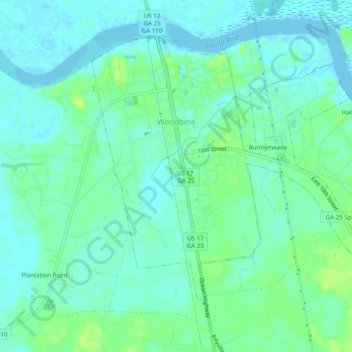
Naam: Topografische kaart Woodbine, hoogte, reliëf.
Locatie: Woodbine, Camden County, Georgia, United States (30.94083 -81.73435 30.97384 -81.68541)
Gemiddelde hoogte: 6 m
Minimale hoogte: -4 m
Maximale hoogte: 14 m
Andere topografische kaarten
Klik op een kaart om zijn topografie, zijn hoogte en zijn reliëf te bekijken.
St. Marys
United States > Georgia > Camden County
St. Marys, Camden County, Georgia, United States
Gemiddelde hoogte: 3 m
Kingsland
United States > Georgia > Camden County
Kingsland, Camden County, Georgia, 31548, United States
Gemiddelde hoogte: 5 m
London Hill
United States > Georgia > Camden County
London Hill, Camden County, Georgia, United States
Gemiddelde hoogte: 2 m
Kings Bay Base
United States > Georgia > Camden County
Kings Bay Base, Camden County, Georgia, 31558, United States
Gemiddelde hoogte: 6 m
Satilla River
United States > Georgia > Camden County
Satilla River, Camden County, Georgia, 31568, United States
Gemiddelde hoogte: 4 m
Cumberland Island
United States > Georgia > Camden County
Cumberland Island, Camden County, Georgia, United States
Gemiddelde hoogte: 2 m
Crooked River Plantation
United States > Georgia > Camden County > St. Marys > Crooked River Plantation
Crooked River Plantation, St. Marys, Camden County, Georgia, 31547, United States
Gemiddelde hoogte: 5 m
State of Georgia
United States > Georgia > Camden County > Kingsland
State of Georgia, Kingsland, Camden County, Georgia, United States
Gemiddelde hoogte: 5 m
Tarboro
United States > Georgia > Camden County > Tarboro
Tarboro, Camden County, Georgia, 31568, United States
Gemiddelde hoogte: 5 m
White Oak
United States > Georgia > Camden County > White Oak
White Oak, Camden County, Georgia, United States
Gemiddelde hoogte: 6 m