
Topografische kaart Becconsall
Klik op de kaart om de hoogte weer te geven.
Over deze kaart
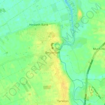
Naam: Topografische kaart Becconsall, hoogte, reliëf.
Gemiddelde hoogte: 10 m
Minimale hoogte: 0 m
Maximale hoogte: 21 m
Andere topografische kaarten
Klik op een kaart om zijn topografie, zijn hoogte en zijn reliëf te bekijken.
Bispham
United Kingdom > England > Lancashire > West Lancashire > Bispham Green
Gemiddelde hoogte: 26 m
Up Holland
United Kingdom > England > Lancashire > West Lancashire > Upholland
Gemiddelde hoogte: 89 m
Scarisbrick
United Kingdom > England > Lancashire > West Lancashire > Scarisbrick
Gemiddelde hoogte: 12 m
Bury Hey Wood
United Kingdom > England > Lancashire > West Lancashire > Appley Bridge > Robin Hood
Gemiddelde hoogte: 106 m
Bickerstaffe
United Kingdom > England > Lancashire > West Lancashire > Bickerstaffe
Gemiddelde hoogte: 51 m
Bury Hey Wood
United Kingdom > England > Lancashire > West Lancashire > Appley Bridge > Robin Hood
Gemiddelde hoogte: 106 m