
Topografische kaart Elands
Interactieve kaart
Klik op de kaart om de hoogte weer te geven.
Over deze kaart
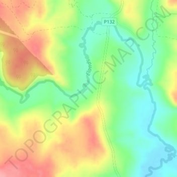
Naam: Topografische kaart Elands, hoogte, reliëf.
Gemiddelde hoogte: 1.315 m
Minimale hoogte: 1.271 m
Maximale hoogte: 1.368 m
Andere topografische kaarten
Klik op een kaart om zijn topografie, zijn hoogte en zijn reliëf te bekijken.
Lotheni
RSA > KwaZulu-Natal > Impendle Local Municipality
Lotheni, Impendle Local Municipality, uMgungundlovu District Municipality, KwaZulu-Natal, RSA
Gemiddelde hoogte: 1.514 m
Elands
RSA > KwaZulu-Natal > Impendle Local Municipality
Elands, Impendle Local Municipality, uMgungundlovu District Municipality, KwaZulu-Natal, RSA
Gemiddelde hoogte: 1.315 m