
Topografische kaart Cerro Punta
Interactieve kaart
Klik op de kaart om de hoogte weer te geven.
Over deze kaart
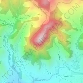
Naam: Topografische kaart Cerro Punta, hoogte, reliëf.
Locatie: Cerro Punta, Distrito Tierras Altas, Chiriquí, Panamá (8.88001 -82.58550 8.88011 -82.58540)
Gemiddelde hoogte: 2.024 m
Minimale hoogte: 1.809 m
Maximale hoogte: 2.368 m
Andere topografische kaarten
Klik op een kaart om zijn topografie, zijn hoogte en zijn reliëf te bekijken.
Nueva California
Panamá > Chiriquí > Distrito Tierras Altas
Nueva California, Distrito Tierras Altas, Chiriquí, Panamá
Gemiddelde hoogte: 1.889 m
Las Nubes
Panamá > Chiriquí > Distrito Tierras Altas
Las Nubes, Cerro Punta, Distrito Tierras Altas, Chiriquí, Panamá
Gemiddelde hoogte: 2.210 m
Volcán Barú
Panamá > Chiriquí > Distrito Tierras Altas > Paso Ancho
Volcán Barú, Paso Ancho, Distrito Tierras Altas, Chiriquí, Panamá
Gemiddelde hoogte: 3.076 m