
Topografische kaart Bloomington
Interactieve kaart
Klik op de kaart om de hoogte weer te geven.
Over deze kaart
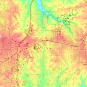
Naam: Topografische kaart Bloomington, hoogte, reliëf.
Locatie: Bloomington, Monroe County, Indiana, United States (39.12133 -86.59189 39.22136 -86.47113)
Gemiddelde hoogte: 241 m
Minimale hoogte: 177 m
Maximale hoogte: 293 m
Bloomington is an area of irregular limestone terrain characterized by sinks, ravines, fissures, underground streams, sinking streams, springs and caves. It is in the rolling hills of southern Indiana, resting on the intersection of the Norman Uplands and the Mitchell Plain. The city's relatively varied topography is a sharp contrast to the flatter terrain more typical of central to northern portions of Indiana.
Andere topografische kaarten
Klik op een kaart om zijn topografie, zijn hoogte en zijn reliëf te bekijken.
Clear Creek
United States > Indiana > Monroe County > Clear Creek
Clear Creek, Monroe County, Indiana, United States
Gemiddelde hoogte: 218 m
University Lake Dam
United States > Indiana > Monroe County > Bloomington
University Lake Dam, Bloomington, Monroe County, Indiana, 47408, United States
Gemiddelde hoogte: 236 m
Upper Cascades Park
United States > Indiana > Monroe County > Bloomington
Upper Cascades Park, Bloomington, Monroe County, Indiana, United States
Gemiddelde hoogte: 217 m
Ellettsville
United States > Indiana > Monroe County
Ellettsville, Monroe County, Indiana, United States
Gemiddelde hoogte: 235 m
Broadview
United States > Indiana > Monroe County > Bloomington
Broadview, Bloomington, Monroe County, Indiana, 47402, United States
Gemiddelde hoogte: 231 m