
Topografische kaart Sky Valley
Interactieve kaart
Klik op de kaart om de hoogte weer te geven.
Over deze kaart
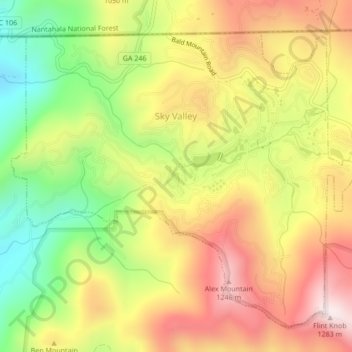
Naam: Topografische kaart Sky Valley, hoogte, reliëf.
Locatie: Sky Valley, Rabun County, Georgia, 30537, United States (34.96659 -83.35311 34.99589 -83.31062)
Gemiddelde hoogte: 973 m
Minimale hoogte: 652 m
Maximale hoogte: 1.275 m
According to the United States Census Bureau, the city has a total area of 3.0 square miles (7.8 km2), all land. The elevation of the valley floor is approximately 3100 feet above sea level, while areas within the city limits on the slopes of Rabun Bald exceed 4200 feet. Sky Valley is Georgia's highest incorporated city and one of the highest municipalities in the eastern United States.
Andere topografische kaarten
Klik op een kaart om zijn topografie, zijn hoogte en zijn reliëf te bekijken.
Mountain City
United States > Georgia > Rabun County
Mountain City, Rabun County, Georgia, 30562, United States
Gemiddelde hoogte: 747 m
Chestnut Mountain
United States > Georgia > Rabun County
Chestnut Mountain, Rabun County, Georgia, 30537, United States
Gemiddelde hoogte: 834 m
Clayton
United States > Georgia > Rabun County
Clayton, Rabun County, Georgia, 30525, United States
Gemiddelde hoogte: 621 m
Elisha Mountain
United States > Georgia > Rabun County
Elisha Mountain, Rabun County, Georgia, 30525, United States
Gemiddelde hoogte: 828 m
Lake Burton
United States > Georgia > Rabun County
Lake Burton, Rabun County, Georgia, United States
Gemiddelde hoogte: 662 m
Blalock
United States > Georgia > Rabun County
Blalock, Rabun County, Georgia, United States
Gemiddelde hoogte: 682 m
Black Rock Mountain State Park
United States > Georgia > Rabun County > Mountain City
Black Rock Mountain State Park, Mountain City, Rabun County, Georgia, United States
Gemiddelde hoogte: 833 m
Tallulah Gorge State Park
United States > Georgia > Rabun County > Tallulah Falls
Tallulah Gorge State Park, Tallulah Falls, Rabun County, Georgia, United States
Gemiddelde hoogte: 435 m
Tallulah Gorge
United States > Georgia > Rabun County > Tallulah Falls
Tallulah Gorge, Tallulah Falls, Rabun County, Georgia, United States
Gemiddelde hoogte: 465 m
Lakemont
United States > Georgia > Rabun County
Lakemont, Rabun County, Georgia, 30581, United States
Gemiddelde hoogte: 547 m
Dillard
United States > Georgia > Rabun County
Dillard, Rabun County, Georgia, United States
Gemiddelde hoogte: 691 m
Rabun Gap Nacoochee School Lake
United States > Georgia > Rabun County
Rabun Gap Nacoochee School Lake, Rabun County, Georgia, United States
Gemiddelde hoogte: 671 m
Ben Mountain
United States > Georgia > Rabun County
Ben Mountain, Rabun County, Georgia, 30537, United States
Gemiddelde hoogte: 866 m
Rabun Gap Nacoochee School Lake Dam
United States > Georgia > Rabun County
Rabun Gap Nacoochee School Lake Dam, Rabun County, Georgia, 30568, United States
Gemiddelde hoogte: 671 m
Lake Seed
United States > Georgia > Rabun County
Lake Seed, Rabun County, Georgia, United States
Gemiddelde hoogte: 653 m